
File:Southern Leyte mudslide 2006 pic01.jpg
預覽大小:800 × 531 像素。 其他解析度:320 × 212 像素 | 640 × 425 像素 | 1,024 × 680 像素 | 1,280 × 850 像素 | 2,560 × 1,700 像素 | 3,225 × 2,141 像素。
原始檔案 (3,225 × 2,141 像素,檔案大小:4.61 MB,MIME 類型:image/jpeg)
| 描述 |
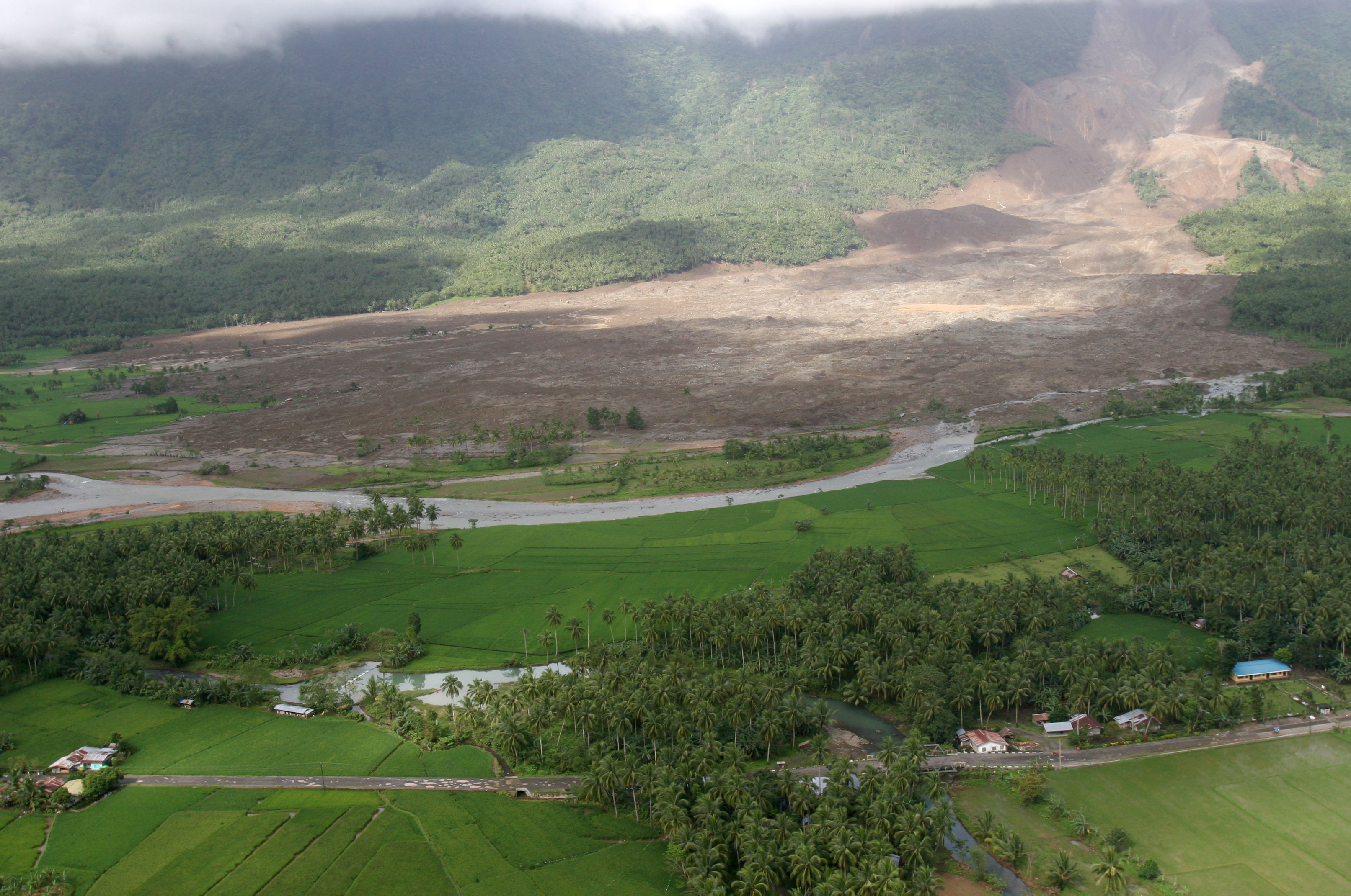
English: 060219-M-8084P-001 Saint Bernard, Republic of the Philippines (Feb. 19, 2006) - An aerial view of the mudslide, which destroyed the town of Guinsahugon the morning of Feb. 17. Guinsahugon is located in the southern part of the island of Leyte in the Philippines. The photo was taken from a CH-46E Sea Knight which was being flown to Guinsahugon to deliver relief supplies. The helicopter is from the 31st Marine Expeditionary Unit's aviation combat element Marine Medium Helicopter Squadron 262 (Reinforced). The MEU, based out of Okinawa, Japan, is deployed to the Philippines as part of the Forward Deployed Amphibious Ready Group (ARG) based out of Sasebo, Japan and was in the Philippines to take part in exercise Balikatan 2006 before responding to a request for aid by the Philippine government. U.S. Marine Corps photo by Lance Cpl. Raymond D. Petersen III (RELEASED)
Deutsch: Schlammlawine |
||||||
| 日期 | |||||||
| 來源 | http://www.navy.mil/view_image.asp?id=32089 | ||||||
| 作者 | Raymond D. Petersen III | ||||||
| 授權許可 (重用此檔案) |
|
||||||

檔案歷史
點選日期/時間以檢視該時間的檔案版本。
| 日期/時間 | 縮圖 | 尺寸 | 用戶 | 備註 | |
|---|---|---|---|---|---|
| 目前 | 2006年2月20日 (一) 12:42 | | 3,225 × 2,141(4.61 MB) | Stefan Kühn | {{PD-USGov-Military-Navy}} Source: http://www.navy.mil/view_single.asp?id=32089 060219-M-8084P-001 Saint Bernard, Republic of the Philippines (Feb. 19, 2006) - An aerial view of the mudslide, which destroyed the town of Guinsahugon the morning of Feb. 1 |
檔案用途
下列2個頁面有用到此檔案:
全域檔案使用狀況
以下其他 wiki 使用了這個檔案:
- ceb.wikipedia.org 的使用狀況
- de.wikipedia.org 的使用狀況
- en.wikipedia.org 的使用狀況
- es.wikipedia.org 的使用狀況
- fi.wikipedia.org 的使用狀況
- fr.wikipedia.org 的使用狀況
- hi.wikipedia.org 的使用狀況
- id.wikipedia.org 的使用狀況
- it.wikipedia.org 的使用狀況
- ja.wikipedia.org 的使用狀況
- ka.wikipedia.org 的使用狀況
- mk.wikipedia.org 的使用狀況
- ru.wikipedia.org 的使用狀況
- sv.wikipedia.org 的使用狀況
- tl.wikipedia.org 的使用狀況
- zh-classical.wikipedia.org 的使用狀況
- zh-min-nan.wikipedia.org 的使用狀況