
File:The Old Town Hall - geograph.org.uk - 1042854.jpg
The_Old_Town_Hall_-_geograph.org.uk_-_1042854.jpg (640 × 426 像素,檔案大小:82 KB,MIME 類型:image/jpeg)
摘要
| 描述 |
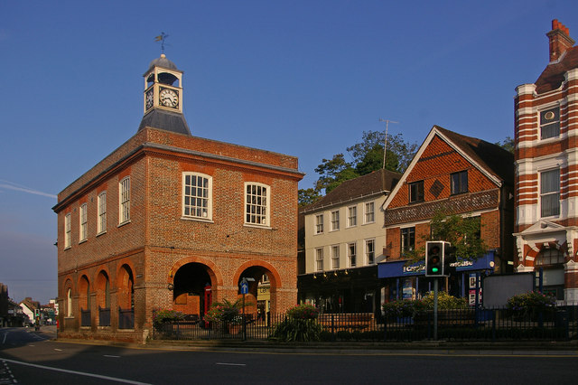
English: The Old Town Hall. This grade II* listed building (for listing particulars see http://www.heritagegateway.org.uk/Gateway/Results_Single.aspx?uid=289342&resourceID=5) was built in around 1728 as a replacement market hall for a similar building that once stood near West Street.
The cupola and clock were added in 1811 having been removed from the recently demolished nearby town prison ("the cage" - a new prison cage was built in what is now Cage Yard - see 1042857). In 1853, a chimney was added in each corner during alterations carried out by Lord Somers (who owned much of Reigate at the time) - they were removed in the 1980s, being out of keeping with the remainder of the building. It served as the town hall from 1863 to 1901, when the role transferred to the new municipal buildings in Castlefield Road (see 630757), after which it gained the name "Old Town Hall" by which it is now generally known. The building was used for petty court sessions from 1876, magistrates sitting there into the 1880s. It has been owned by the local council since 1922, with recent use including art and photographic exhibitions. However, following much debate over a longer term use to justify restoration, in 2008 it became a Caffe Nero coffee shop. Note the reference to a former user of the shop premises to the right of the building (now Carphone Warehouse) - Eames Outfitters; the building itself dates from the early 17th century and is grade II listed. |
| 日期 | |
| 來源 | From geograph.org.uk |
| 作者 | Ian Capper |
| 姓名標示 (由许可协议要求) | Ian Capper / The Old Town Hall / |
| 拍攝地點 | | 位於此地的本圖片與其他圖片: OpenStreetMap |
|---|
_heading:292.00&language=zh-mo)
| 目標地點 | | 位於此地的本圖片與其他圖片: OpenStreetMap |
|---|
_heading:292.00&language=zh-mo)
授權條款

|
- 您可以自由:
- 分享 – 複製、發佈和傳播本作品
- 重新修改 – 創作演繹作品
- 惟需遵照下列條件:
- 姓名標示 – 您必須指名出正確的製作者,和提供授權條款的連結,以及表示是否有對內容上做出變更。您可以用任何合理的方式來行動,但不得以任何方式表明授權條款是對您許可或是由您所使用。
- 相同方式分享 – 如果您利用本素材進行再混合、轉換或創作,您必須基於如同原先的相同或兼容的條款,來分布您的貢獻成品。
檔案歷史
點選日期/時間以檢視該時間的檔案版本。
| 日期/時間 | 縮圖 | 尺寸 | 用戶 | 備註 | |
|---|---|---|---|---|---|
| 目前 | 2011年2月23日 (三) 22:41 | | 640 × 426(82 KB) | GeographBot | == {{int:filedesc}} == {{Information |description={{en|1=The Old Town Hall This grade II* listed building (for listing particulars see http://www.heritagegateway.org.uk/Gateway/Results_Single.aspx?uid=289342&resourceID=5) was built in around 1728 as a rep |
檔案用途
下列頁面有用到此檔案:
全域檔案使用狀況
以下其他 wiki 使用了這個檔案:
- azb.wikipedia.org 的使用狀況
- en.wikipedia.org 的使用狀況
- en.wikivoyage.org 的使用狀況
- fa.wikipedia.org 的使用狀況
- lt.wikipedia.org 的使用狀況
- nl.wikipedia.org 的使用狀況
- pt.wikipedia.org 的使用狀況
- ru.wikipedia.org 的使用狀況