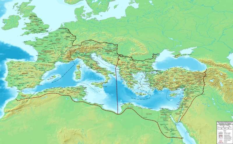
File:The Roman Empire ca 400 AD.png

預覽大小:800 × 496 像素。 其他解析度:320 × 198 像素 | 640 × 397 像素 | 1,024 × 635 像素 | 1,280 × 793 像素 | 2,560 × 1,587 像素 | 4,339 × 2,689 像素。
原始檔案 (4,339 × 2,689 像素,檔案大小:12.8 MB,MIME 類型:image/png)
檔案歷史
點選日期/時間以檢視該時間的檔案版本。
| 日期/時間 | 縮圖 | 尺寸 | 用戶 | 備註 | |
|---|---|---|---|---|---|
| 目前 | 2015年2月19日 (四) 22:27 |  | 4,339 × 2,689(12.8 MB) | Cplakidas | added potential location of Valentia beyond Hadrian's Wall, removed provincial boundaries in Britannia as too tentative |
| 2011年7月21日 (四) 13:03 |  | 4,339 × 2,689(10.9 MB) | Cplakidas | fixed Persian border, differentiated between Eastern and Western empire, different borders for praet. prefectures | |
| 2009年3月21日 (六) 02:37 |  | 4,475 × 2,600(9.99 MB) | Cplakidas | minor corrections | |
| 2008年5月29日 (四) 12:30 |  | 3,800 × 2,370(8.1 MB) | Cplakidas | ||
| 2008年5月29日 (四) 12:17 |  | 4,560 × 2,850(11.22 MB) | Cplakidas | clearer version & addition of the Armenian satrapies | |
| 2007年12月30日 (日) 02:02 |  | 3,380 × 2,120(5.96 MB) | Cplakidas | added names of dioceses, legend box, various minor adjustments | |
| 2007年12月13日 (四) 14:27 |  | 3,550 × 2,200(6.65 MB) | Cplakidas | new improved version made with Inkscape, slight corrections in borders, added several cities in Africa & Spain | |
| 2007年11月12日 (一) 19:27 |  | 3,550 × 2,200(4.75 MB) | Cplakidas | minor corrections in southern Gaul | |
| 2007年11月5日 (一) 12:58 |  | 3,550 × 2,200(4.75 MB) | Cplakidas | New version, with some corrections & additions | |
| 2007年10月31日 (三) 16:55 |  | 3,436 × 2,142(4.5 MB) | Cplakidas | {{Information |Description=Map of the Roman Empire ca. 400 AD, showing the administrative division into dioceses and provinces, as well as the major cities. The demarcation between Eastern and Western Empires is noted in red. |Source=Base map found at |
檔案用途
下列頁面有用到此檔案:
全域檔案使用狀況
以下其他 wiki 使用了這個檔案:
- af.wikipedia.org 的使用狀況
- ar.wikipedia.org 的使用狀況
- ary.wikipedia.org 的使用狀況
- ast.wikipedia.org 的使用狀況
- bg.wikipedia.org 的使用狀況
- bn.wikipedia.org 的使用狀況
- ca.wikipedia.org 的使用狀況
- ceb.wikipedia.org 的使用狀況
- cs.wikipedia.org 的使用狀況
- de.wikipedia.org 的使用狀況
- el.wikipedia.org 的使用狀況
- en.wikipedia.org 的使用狀況
- eo.wikipedia.org 的使用狀況
- es.wikipedia.org 的使用狀況
- et.wikipedia.org 的使用狀況
- fr.wikipedia.org 的使用狀況
- he.wikipedia.org 的使用狀況
- hi.wikipedia.org 的使用狀況
- hr.wikipedia.org 的使用狀況
- hu.wikipedia.org 的使用狀況
- id.wikipedia.org 的使用狀況
- it.wikipedia.org 的使用狀況
- ko.wikipedia.org 的使用狀況
- la.wikipedia.org 的使用狀況
- lt.wikipedia.org 的使用狀況
檢視此檔案的更多全域使用狀況。


