
File:Volga German03.png

預覽大小:576 × 600 像素。 其他解析度:230 × 240 像素 | 626 × 652 像素。
原始檔案 (626 × 652 像素,檔案大小:46 KB,MIME 類型:image/png)
摘要
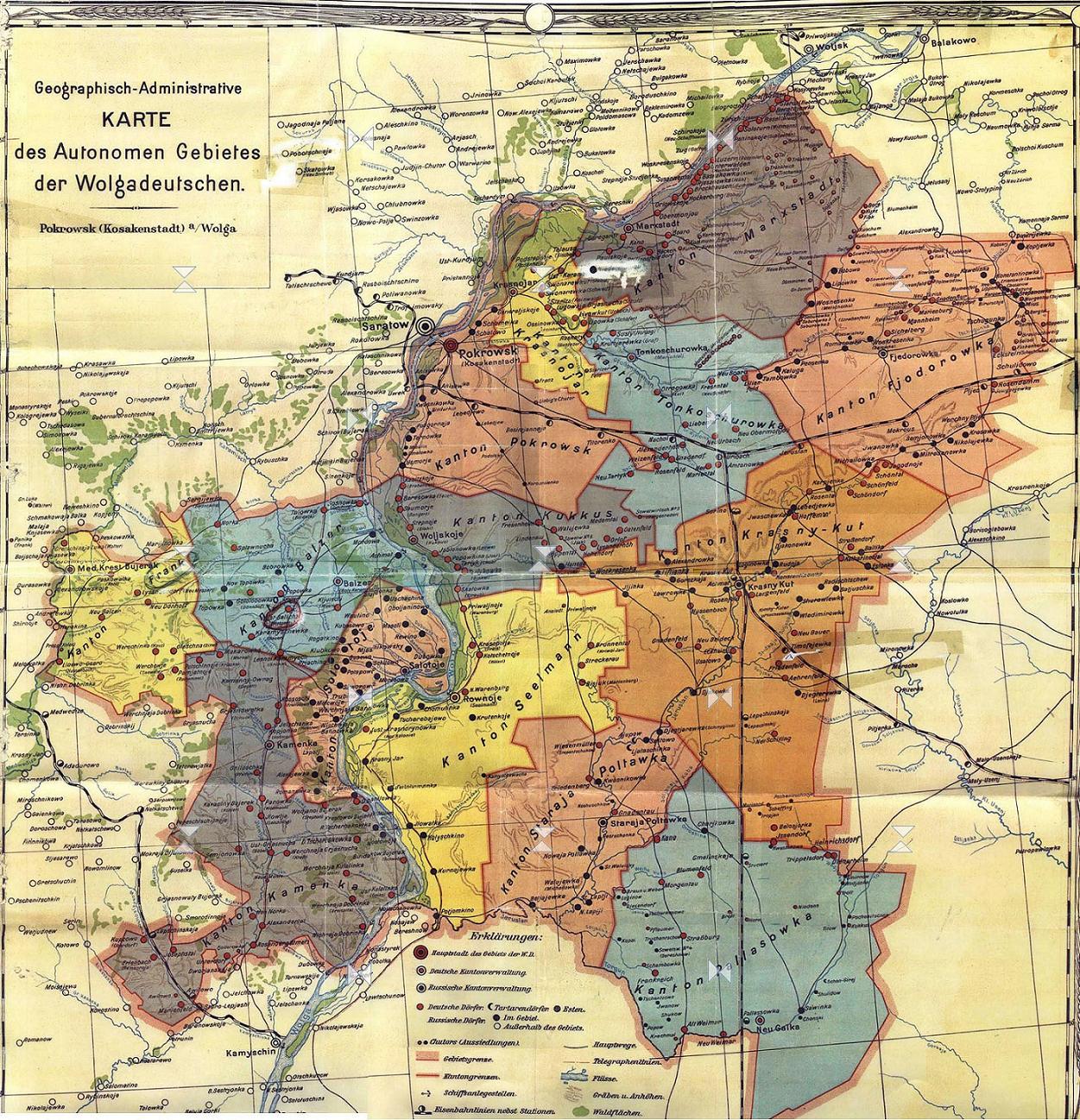
| 描述 | This is an map of the former Volga German Autonomous Soviet Socialist Republic (Volga German ASSR) that existed from 1924 to 1941. It shows the location of major settlements, including the capital, Engels (Pokrovsk). |
| 日期 | 2006年十二月29日 (原始上傳日期) |
| 來源 | 自己的作品 |
| 作者 | PANONIAN |
Source and license

|
This map has been uploaded by Electionworld from en.wikipedia.org to enable the |
historic map (self made by user:PANONIAN)
授權條款
| 我,此作品的版權所有人,釋出此作品至公共領域。此授權條款在全世界均適用。 這可能在某些國家不合法,如果是的話: 我授予任何人有權利使用此作品於任何用途,除受法律約束外,不受任何限制。 |
References
- http://terkepek.adatbank.transindex.ro/kepek/netre/24.gif
- http://www.zum.de/whkmla/histatlas/russia/volgagermanassr2t.gif
- http://www.zum.de/whkmla/histatlas/russia/volgagermanassr2.gif
- http://cvgs.cu-portland.edu/images/map_vg_republic_index.jpg
- http://www.volgagermans.net/norka/images/Volga-German-ASSR-1928-1600px.jpg
- http://www.frank-kolb-russia.org/images/volga-german-assr.jpg
- http://www2.ku.edu/~germanic/LAKGD/Dinges/Dinges1.jpg
- http://images.ookaboo.com/photo/m/Volga_Oblasts_and_ASSRs_in_1940_m.jpg
- http://www.rusdeutsch.ru/image/history/Glava8/АССР%20немцев%20Поволжья%20в%201941%20г..jpg
- http://wolgadeutsche.ru/karten/ASSRdWD.jpg
- http://wolgadeutsche.net/lexikon/img/ASSRdWD.jpg
- http://wolgadeutsche.net/lexikon/img/Saratow_kraj_1934b.jpg
- http://wolgadeutsche.net/lexikon/img/ASSRdWD_1938.jpg
- http://s40.radikal.ru/i088/1001/12/652dcba6b7e8.jpg
- http://www.schuk.ru/1/maps/1935.jpg
- http://upload.wikimedia.org/wikipedia/de/7/7f/Wolgadeutsche_ASSR.jpg
- http://genze.webstolica.ru/_mod_files/ce_images/Volga/volgade_-_1923.jpg
- http://dic.academic.ru/pictures/wiki/files/86/Volga_Oblasts_and_ASSRs_in_1940.jpg
- http://minchanin.esmasoft.com/maps/ussr1939/maps/20.jpg
- http://upload.wikimedia.org/wikipedia/commons/8/8c/Volga_Oblasts_and_ASSRs_in_1940.jpg
- http://upload.wikimedia.org/wikipedia/commons/9/9e/Karta_AGW_1922.jpg
- http://upload.wikimedia.org/wikipedia/ru/2/2e/АССР_Немцев_Поволжья.png
檔案歷史
點選日期/時間以檢視該時間的檔案版本。
| 日期/時間 | 縮圖 | 尺寸 | 用戶 | 備註 | |
|---|---|---|---|---|---|
| 目前 | 2012年7月15日 (日) 15:07 | | 626 × 652(46 KB) | PANONIAN | improved version |
| 2006年12月29日 (五) 13:11 |  | 523 × 524(17 KB) | Electionworld | {{ew|en|PANONIAN}} historic map (self made) {{PD-self}} Category:Maps of the history of Russia |
檔案用途
下列2個頁面有用到此檔案:
全域檔案使用狀況
以下其他 wiki 使用了這個檔案:
- az.wikipedia.org 的使用狀況
- ba.wikipedia.org 的使用狀況
- be-tarask.wikipedia.org 的使用狀況
- be.wikipedia.org 的使用狀況
- bg.wikipedia.org 的使用狀況
- br.wikipedia.org 的使用狀況
- ca.wikipedia.org 的使用狀況
- cs.wikipedia.org 的使用狀況
- da.wikipedia.org 的使用狀況
- de.wikipedia.org 的使用狀況
- en.wikipedia.org 的使用狀況
- eo.wikipedia.org 的使用狀況
- es.wikipedia.org 的使用狀況
- fa.wikipedia.org 的使用狀況
- fi.wikipedia.org 的使用狀況
- fr.wikipedia.org 的使用狀況
- gl.wikipedia.org 的使用狀況
- hsb.wikipedia.org 的使用狀況
- hu.wikipedia.org 的使用狀況
- it.wikipedia.org 的使用狀況
- ja.wikipedia.org 的使用狀況
- ko.wikipedia.org 的使用狀況
- lt.wikipedia.org 的使用狀況
- pt.wikipedia.org 的使用狀況
- ro.wikipedia.org 的使用狀況
- ru.wikipedia.org 的使用狀況
- sh.wikipedia.org 的使用狀況
- sr.wikipedia.org 的使用狀況
- tr.wikipedia.org 的使用狀況
- uk.wikipedia.org 的使用狀況