
File:Androscoggin County Maine Incorporated Areas Livermore Falls Highlighted.png
此為最大尺寸。
Androscoggin_County_Maine_Incorporated_Areas_Livermore_Falls_Highlighted.png (450 × 386 像素,檔案大小:31 KB,MIME 類型:image/png)
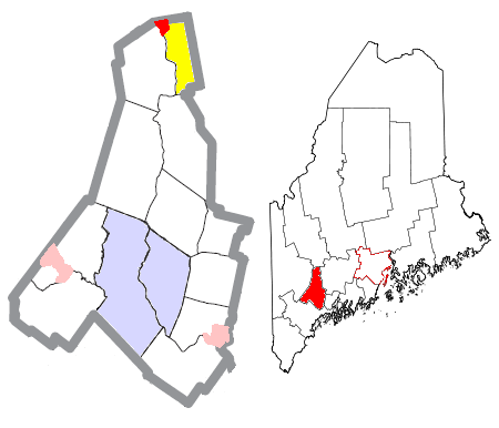
| 描述 | Map of the divisions of Androscoggin County, Maine, United States, with Livermore Falls highlighted: the census-designated place of Livermore Falls in red, and the rest of the town of Livermore Falls in yellow. The cities of Auburn and Lewiston are light blue; other towns are white; and pink areas are census-designated places within other towns. | ||
| 日期 | |||
| 來源 | Modified by me from this United States Census Bureau file. | ||
| 作者 | Nyttend | ||
| 授權許可 (重用此檔案) |
US Government work is public domain, and my work is
|
檔案歷史
點選日期/時間以檢視該時間的檔案版本。
| 日期/時間 | 縮圖 | 尺寸 | 使用者 | 備註 | |
|---|---|---|---|---|---|
| 目前 | 2008年6月25日 (三) 20:26 | | 450 × 386(31 KB) | Nyttend | {{Information |Description=Map of the divisions of {{w|Androscoggin County, Maine|Androscoggin County}}, {{w|Maine}}, {{w|United States}}, with Livermore Falls highlighted: the {{w|census-designated place}} of {{w|Livermore Falls (CDP), Maine|Livermore Fa |
檔案用途
下列2個頁面有用到此檔案:
全域檔案使用狀況
以下其他 wiki 使用了這個檔案:
- ar.wikipedia.org 的使用狀況
- azb.wikipedia.org 的使用狀況
- en.wikipedia.org 的使用狀況
- fa.wikipedia.org 的使用狀況
- tt.wikipedia.org 的使用狀況
- www.wikidata.org 的使用狀況