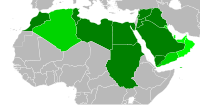
File:Arab League 1971.svg
外觀

此 SVG 檔案的 PNG 預覽的大小:200 × 105 像素。 其他解析度:320 × 168 像素 | 640 × 336 像素 | 1,024 × 538 像素 | 1,280 × 672 像素 | 2,560 × 1,344 像素。
原始檔案 (SVG 檔案,表面大小:200 × 105 像素,檔案大小:1.25 MB)
檔案歷史
點選日期/時間以檢視該時間的檔案版本。
| 日期/時間 | 縮圖 | 尺寸 | 使用者 | 備註 | |
|---|---|---|---|---|---|
| 目前 | 2011年12月28日 (三) 19:23 |  | 200 × 105(1.25 MB) | Quintucket | Western Sahara border. You see... I made maps for every expansion, but not in order (Don't know if I should upload them, but I made them, then this set showing multiple expansions to replace the ones used on Wikipedia. Thus, when I created the 1971 expa |
| 2011年12月27日 (二) 08:39 |  | 200 × 105(1.25 MB) | Quintucket | {{Information |Description ={{en|1=Map of the Arab League in 1971. Contemporary borders for states that will join the Arab League, modern borders for other African state. Based on File:BlankMap-World6-Equirectangular.svg, which is released under |
檔案用途
下列2個頁面有用到此檔案:
全域檔案使用狀況
以下其他 wiki 使用了這個檔案:
- ar.wikipedia.org 的使用狀況
- bn.wikipedia.org 的使用狀況
- en.wikipedia.org 的使用狀況
- pt.wikipedia.org 的使用狀況

