
File:Beylik of Aydın 1315-1375.png

預覽大小:800 × 394 像素。 其他解析度:320 × 157 像素 | 640 × 315 像素 | 1,024 × 504 像素 | 1,280 × 630 像素 | 2,560 × 1,259 像素 | 8,923 × 4,390 像素。
原始檔案 (8,923 × 4,390 像素,檔案大小:1.22 MB,MIME 類型:image/png)
摘要
Look also: User:Berkaysnklf/Turkey
.
.
| 描述 |
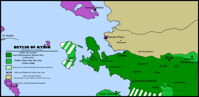
English: Beylik of Aydın(Aydınids)'s map during its peak years between 1315 and 1375. Beylik of Aydın Map highlighting: Borders under Gazi Mehmed Bey Borders after conquests under Umur Bey the Lion Byzantine Empire territories Other Western Anatolian Beyliks Black "X" showing Umur Bey's aids Red "X" showing Umur Bey's raids Türkçe: Aydınoğulları Beyliği'nin en parlak dönemleri olan 1315-1375 yılları arasındaki sınırlarını gösteren siyasi harita. Aydınoğulları Beyliği Haritası İçeriği: Gazi Mehmet Bey döneminde sınırlar Umur Bey fetihleri sonrasında sınırlar Bizans İmparatorluğu toprakları Diğer Batı Anadolu Beylikleri Siyah "X" Umur Bey'in yardımlarını gösterirKırmızı "X" Umur Bey'in yağmalarını gösterir |
||||||
| 日期 | |||||||
| 來源 | 自己的作品 | ||||||
| 作者 |
|
||||||
| 授權許可 (重用此檔案) |
|
||||||
| 其他版本 |
|

授權條款
我,本作品的著作權持有者,決定用以下授權條款發佈本作品:
此檔案採用創用CC 姓名標示 4.0 國際授權條款。
- 您可以自由:
- 分享 – 複製、發佈和傳播本作品
- 重新修改 – 創作演繹作品
- 惟需遵照下列條件:
- 姓名標示 – 您必須指名出正確的製作者,和提供授權條款的連結,以及表示是否有對內容上做出變更。您可以用任何合理的方式來行動,但不得以任何方式表明授權條款是對您許可或是由您所使用。
檔案歷史
點選日期/時間以檢視該時間的檔案版本。
| 日期/時間 | 縮圖 | 尺寸 | 使用者 | 備註 | |
|---|---|---|---|---|---|
| 目前 | 2015年1月23日 (五) 22:17 | | 8,923 × 4,390(1.22 MB) | BRKY24 | User created page with UploadWizard |
檔案用途
下列頁面有用到此檔案:
全域檔案使用狀況
以下其他 wiki 使用了這個檔案:
- als.wikipedia.org 的使用狀況
- ar.wikipedia.org 的使用狀況
- bg.wikipedia.org 的使用狀況
- cs.wikipedia.org 的使用狀況
- de.wikipedia.org 的使用狀況
- en.wikipedia.org 的使用狀況
- fr.wikipedia.org 的使用狀況
- pt.wikipedia.org 的使用狀況
- sl.wikipedia.org 的使用狀況
- www.wikidata.org 的使用狀況