
File:Bono Archaeological Site.jpg

預覽大小:800 × 450 像素。 其他解析度:320 × 180 像素 | 640 × 360 像素 | 1,024 × 576 像素 | 1,280 × 720 像素 | 2,816 × 1,584 像素。
原始檔案 (2,816 × 1,584 像素,檔案大小:1.81 MB,MIME 類型:image/jpeg)
| 拍攝地點 | | 位於此地的本圖片與其他圖片: OpenStreetMap |
|---|
| 描述 |
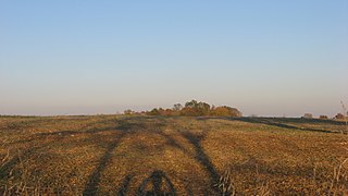
English: Western edge of the Bono Archaeological Site, located on the eastern side of Bono-Tunnelton Road above the East Fork of the White River and one mile north of Bono in Bono Township, Lawrence County, Indiana, United States. Most of the field is a clam shell midden and thus a valuable archaeological site; it is listed on the National Register of Historic Places. |
||
| 日期 | 攝於2011年10月8日 | ||
| 來源 | 自己的作品 | ||
| 作者 | Nyttend | ||
| 授權許可 (重用此檔案) |
|
檔案歷史
點選日期/時間以檢視該時間的檔案版本。
| 日期/時間 | 縮圖 | 尺寸 | 使用者 | 備註 | |
|---|---|---|---|---|---|
| 目前 | 2011年10月9日 (日) 12:27 | | 2,816 × 1,584(1.81 MB) | Nyttend | {{Location|38|44|42|N|86|19|54|W}} {{Information |Description={{en|Western edge of the {{w|Bono Archaeological Site}}, located on the eastern side of Bono-Tunnelton Road above the East Fork of the {{w|White River (Indiana)|White River}} and one mile north |
檔案用途
下列頁面有用到此檔案:
全域檔案使用狀況
以下其他 wiki 使用了這個檔案:
- en.wikipedia.org 的使用狀況
- es.wikipedia.org 的使用狀況
- eu.wikipedia.org 的使用狀況
- ur.wikipedia.org 的使用狀況
- vi.wikipedia.org 的使用狀況
- www.wikidata.org 的使用狀況