
File:British National Grid.svg

此 SVG 檔案的 PNG 預覽的大小:204 × 377 像素。 其他解析度:130 × 240 像素 | 260 × 480 像素 | 415 × 768 像素 | 554 × 1,024 像素 | 1,108 × 2,048 像素。
原始檔案 (SVG 檔案,表面大小:204 × 377 像素,檔案大小:78 KB)
| 描述 |
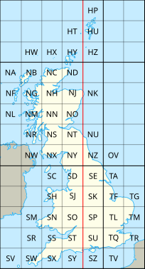
English: The en:British national grid reference system |
| 日期 | (UTC) |
| 來源 | |
| 作者 |
|
| 其他版本 |
|

此檔案採用創用CC 姓名標示-相同方式分享 3.0 未在地化版本授權條款。
- 您可以自由:
- 分享 – 複製、發佈和傳播本作品
- 重新修改 – 創作演繹作品
- 惟需遵照下列條件:
- 姓名標示 – 您必須指名出正確的製作者,和提供授權條款的連結,以及表示是否有對內容上做出變更。您可以用任何合理的方式來行動,但不得以任何方式表明授權條款是對您許可或是由您所使用。
- 相同方式分享 – 如果您利用本素材進行再混合、轉換或創作,您必須基於如同原先的相同或兼容的條款,來分布您的貢獻成品。
原始上傳日誌
This image is a derivative work of the following images:
- File:National_Grid_for_Great_Britain_with_central_meridian.gif licensed with Cc-by-sa-3.0-migrated, GFDL
- 2010-02-23T23:22:36Z MansLaughter 235x434 (8630 Bytes) {{Information |Description= |Source=*[[:File:National_Grid_for_Great_Britain_with_central_meridian.png|]] |Date=2010-02-23 23:19 (UTC) |Author=*[[:File:National_Grid_for_Great_Britain_with_central_meridian.png|]]: ~~~ *deriva
- File:United_Kingdom_and_North-West_France.svg licensed with Cc-by-sa-3.0
- 2010-04-26T11:43:17Z Pethrus 270x482 (59564 Bytes) {{Information |Description={{en|Map of the United Kingdom and the North-East of France}}{{fr|Carte des îles britanniques et du Nord-Ouest de la France}} |Source=*[[:File:Europe_blank_laea_location_map.svg|]] |Date=2010-04-26
Uploaded with derivativeFX
檔案歷史
點選日期/時間以檢視該時間的檔案版本。
| 日期/時間 | 縮圖 | 尺寸 | 使用者 | 備註 | |
|---|---|---|---|---|---|
| 目前 | 2010年7月8日 (四) 20:06 | | 204 × 377(78 KB) | Nandhp | Remove temporary data (reference to original raster image) |
| 2010年7月8日 (四) 20:05 |  | 204 × 377(83 KB) | Nandhp | {{Information |Description={{en|The en:British national grid reference system}} |Source=*File:National_Grid_for_Great_Britain_with_central_meridian.gif *File:United_Kingdom_and_North-West_France.svg |Date=2010-07-08 20:03 (UTC) |Author=*[ |
檔案用途
下列頁面有用到此檔案:
全域檔案使用狀況
以下其他 wiki 使用了這個檔案:
- de.wikipedia.org 的使用狀況
- en.wikipedia.org 的使用狀況
- en.wikivoyage.org 的使用狀況
- fr.wikipedia.org 的使用狀況
- nl.wikipedia.org 的使用狀況
- simple.wikipedia.org 的使用狀況