
File:Canton1860.jpg

預覽大小:800 × 457 像素。 其他解析度:320 × 183 像素 | 640 × 366 像素 | 1,024 × 585 像素 | 1,280 × 731 像素 | 2,560 × 1,462 像素 | 11,680 × 6,672 像素。
原始檔案 (11,680 × 6,672 像素,檔案大小:11.72 MB,MIME 類型:image/jpeg)
| 警告 | 部分瀏覽器在瀏覽此圖片的完整大小時可能會遇到困難:該圖片中有數量巨大的像素點,可能無法完全載入或者導致您的瀏覽器停止回應。 |
|---|
摘要
| 描寫 |
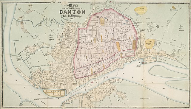
English: "Map of the City and Entire Suburbs of Canton in 1860 by Rev. D. Vrooman", an updating of Vrooman's 1855 map of the city, incorporating the destruction of the Thirteen Factories, the erection of Shamian, and minor adjustments to his prospective map of the city following its opening to foreign visitors following the treaties of Tianjin and Beijing.
中文(简体):广州市1860年地图,藏于澳洲国家图书馆。
中文(繁體):廣州市1860年地圖,藏於澳洲國家圖書館。 |
||||||||||||||||
| 日期 | |||||||||||||||||
| 來源 | http://www.nla.gov.au/apps/cdview/nla.map-lms636 | ||||||||||||||||
| 創作作者 |
|
||||||||||||||||
| Geotemporal data | |||||||||||||||||
| 邊框 |
|
||||||||||||||||
| 地理參考 | |||||||||||||||||
| 其他版本 | |||||||||||||||||

授權條款
|
本作品在其來源國以及其他著作權期限是作者逝世後100年或以下的國家與地區屬於公有領域。 | |
| 此作品無已知的著作權限制,亦不受所有相關和鄰接的權利限制。 | |
檔案歷史
點選日期/時間以檢視該時間的檔案版本。
| 日期/時間 | 縮圖 | 尺寸 | 使用者 | 備註 | |
|---|---|---|---|---|---|
| 目前 | 2018年1月17日 (三) 14:25 | | 11,680 × 6,672(11.72 MB) | User-duck | Cropped using CropTool with lossless mode. |
| 2011年8月24日 (三) 10:34 |  | 11,952 × 7,536(13.97 MB) | Gzdavidwong | {{Information |Description ={{en|1=Maps of Canton City in 1860.}} {{zh-hans|1=广州市1860年地图。}} {{zh-hant|1=廣州市1860年地圖。}} |Source ={{own}} |Author =Gzdavidwong |Date =1860 |Permissi |
檔案用途
全域檔案使用狀況
以下其他 wiki 使用了這個檔案:
- en.wikipedia.org 的使用狀況
- fr.wikipedia.org 的使用狀況
- ha.wikipedia.org 的使用狀況
- ja.wikipedia.org 的使用狀況
- mai.wikipedia.org 的使用狀況
- ru.wikipedia.org 的使用狀況
- www.wikidata.org 的使用狀況
- zh-yue.wikipedia.org 的使用狀況