
File:Charlotte 2009 track.png

預覽大小:800 × 495 像素。 其他解析度:320 × 198 像素 | 640 × 396 像素 | 1,024 × 633 像素 | 1,280 × 791 像素 | 2,700 × 1,669 像素。
原始檔案 (2,700 × 1,669 像素,檔案大小:3.84 MB,MIME 類型:image/png)
摘要
| 描述 |
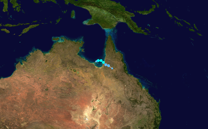
English: Track map of Tropical Cyclone Charlotte of the 2008-09 Australian region cyclone season. The points show the location of the storm at 6-hour intervals. The colour represents the storm's maximum sustained wind speeds as classified in the (see below), and the shape of the data points represent the nature of the storm, according to the legend below. Tropical depression (≤38 mph, ≤62 km/h)
Tropical storm (39–73 mph, 63–118 km/h)
Category 1 (74–95 mph, 119–153 km/h)
Category 2 (96–110 mph, 154–177 km/h)
Category 3 (111–129 mph, 178–208 km/h)
Category 4 (130–156 mph, 209–251 km/h)
Category 5 (≥157 mph, ≥252 km/h)
Unknown
Storm type |
||
| 日期 | 2009-01-10–2009-01-12 | ||
| 來源 | Created by Ramisses using Wikipedia:WikiProject Tropical cyclones/Tracks. The background image is from NASA. Tracking data is from the Joint Typhoon Warning Center[1]. | ||
| 作者 | Ramisses | ||
| Source code | Track map data table, if present below, is in HURDAT2 or ATCF format. See format details in [2] and [3], respectively.
|
授權條款
| 此作品已由其作者,Ramisses,釋出至公有領域。此授權條款在全世界均適用。 這可能在某些國家不合法,如果是的話: Ramisses授予任何人有權利使用此作品於任何用途,除受法律約束外,不受任何限制。 |
檔案歷史
點選日期/時間以檢視該時間的檔案版本。
| 日期/時間 | 縮圖 | 尺寸 | 使用者 | 備註 | |
|---|---|---|---|---|---|
| 目前 | 2020年7月13日 (一) 20:16 | | 2,700 × 1,669(3.84 MB) | Supportstorm | Higher resolution bg |
| 2019年3月22日 (五) 02:56 |  | 2,700 × 1,669(2.62 MB) | Nova Crystallis | Reverted to version as of 20:59, 19 March 2019 (UTC) valid overwrite as an update of the storm track | |
| 2019年3月20日 (三) 03:30 |  | 1,024 × 640(997 KB) | Bidgee | Reverted to version as of 15:46, 13 January 2009 (UTC) COM:OVERWRITE | |
| 2019年3月19日 (二) 20:59 |  | 2,700 × 1,669(2.62 MB) | FleurDeOdile | lol | |
| 2009年1月13日 (二) 15:46 |  | 1,024 × 640(997 KB) | Ramisses | {{Information |Description=Tropical Cyclone Charlotte (2009) track map{{Saffir-Simpson small}} |Source=[http://metocph.nmci.navy.mil/jtwc.php JTWC]. Background image from NASA. |Author=[[User:Ramisses|Ramisse |
檔案用途
下列頁面有用到此檔案:
全域檔案使用狀況
以下其他 wiki 使用了這個檔案:
- de.wikipedia.org 的使用狀況
- en.wikipedia.org 的使用狀況
- es.wikipedia.org 的使用狀況
- pt.wikipedia.org 的使用狀況