
File:Commercial south of First, Worthington.jpg

預覽大小:800 × 450 像素。 其他解析度:320 × 180 像素 | 640 × 360 像素 | 1,024 × 576 像素 | 1,280 × 720 像素 | 2,816 × 1,584 像素。
原始檔案 (2,816 × 1,584 像素,檔案大小:934 KB,MIME 類型:image/jpeg)
| 拍攝地點 | | 位於此地的本圖片與其他圖片: OpenStreetMap |
|---|
| 描述 |
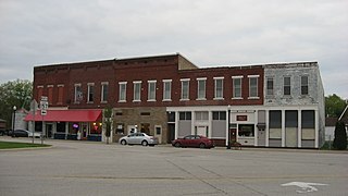
English: Buildings on the eastern side of Commercial Street (U.S. Route 231 and State Roads 67/157) just south of the First Street intersection in central Worthington, Indiana, United States. This spot lies within the local Worthington Commercial Historic District; the buildings were constructed in 1880 and 1915. |
||
| 日期 | 攝於2014年5月1日 | ||
| 來源 | 自己的作品 | ||
| 作者 | Nyttend | ||
| 授權許可 (重用此檔案) |
|
檔案歷史
點選日期/時間以檢視該時間的檔案版本。
| 日期/時間 | 縮圖 | 尺寸 | 使用者 | 備註 | |
|---|---|---|---|---|---|
| 目前 | 2016年1月9日 (六) 17:12 | | 2,816 × 1,584(934 KB) | Nyttend | {{Location|39|7|7|N|86|58|33|W}} {{Information |Description={{en|Buildings on the eastern side of Commercial Street ({{w|U.S. Route 231}} and State Roads {{w|Indiana State Road 67|67}}/{{w|Indiana State Road 157|157}}) just south of the First Street in... |
檔案用途
下列頁面有用到此檔案:
全域檔案使用狀況
以下其他 wiki 使用了這個檔案:
- ar.wikipedia.org 的使用狀況
- azb.wikipedia.org 的使用狀況
- ca.wikipedia.org 的使用狀況
- ceb.wikipedia.org 的使用狀況
- ce.wikipedia.org 的使用狀況
- en.wikipedia.org 的使用狀況
- es.wikipedia.org 的使用狀況
- eu.wikipedia.org 的使用狀況
- ht.wikipedia.org 的使用狀況
- it.wikipedia.org 的使用狀況
- lld.wikipedia.org 的使用狀況
- no.wikipedia.org 的使用狀況
- pl.wikipedia.org 的使用狀況
- pt.wikipedia.org 的使用狀況
- sr.wikipedia.org 的使用狀況
- tt.wikipedia.org 的使用狀況
- uk.wikipedia.org 的使用狀況
- uz.wikipedia.org 的使用狀況
- www.wikidata.org 的使用狀況
- zh-min-nan.wikipedia.org 的使用狀況