
File:Dutch East Indies Expansion.png
預覽大小:800 × 387 像素。 其他解析度:320 × 155 像素 | 923 × 447 像素。
原始檔案 (923 × 447 像素,檔案大小:80 KB,MIME 類型:image/png)
摘要
| 描述 |
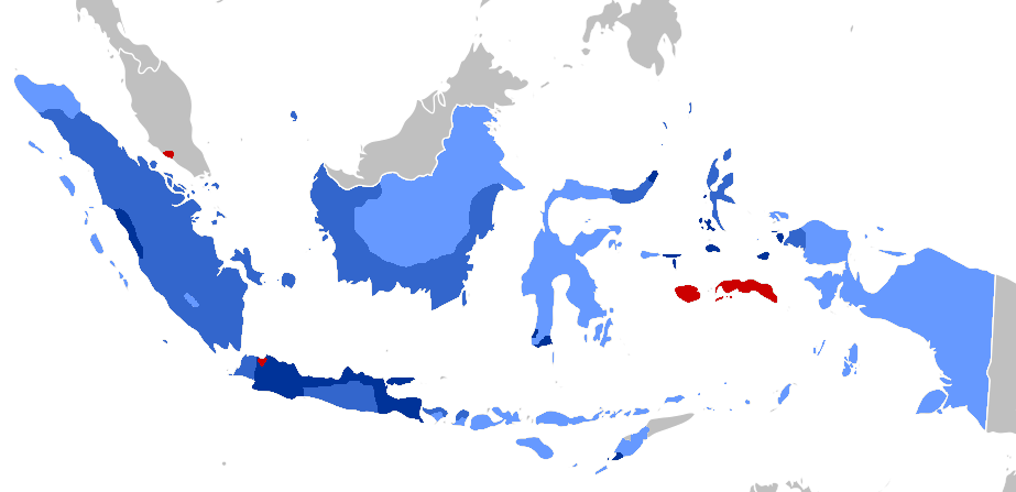
Afrikaans: Periodisering van VOC-territoriale uitbreiding (1619–), en Nederlands-Indië beginnend by 1800:
1600s
1700s
1800s
1900-1942 English: Periodization of VOC territorial expansion, and Dutch East Indies Period from 1800:
1600s
1700s
1800s
1900-1942 Bahasa Indonesia: Periodisasi ekspansi wilayah VOC (1619-1800), Masa Hindia Belanda (1800–1949/1963)
1600an
1700an
1800an
1900-1942 |
| 日期 | |
| 來源 |
The coloring (with GIMP) is based on two maps: The base map is from File:BlankMap-World.svg |
| 作者 | User:AnsyahF |
授權條款
| |
此作品已由其作者,[[::|中文維基百科]]專案的AnsyahF,釋出至公有領域。此授權條款在全世界均適用。 如果法律不適用時: |
檔案歷史
點選日期/時間以檢視該時間的檔案版本。
| 日期/時間 | 縮圖 | 尺寸 | 使用者 | 備註 | |
|---|---|---|---|---|---|
| 目前 | 2020年4月8日 (三) 10:00 | | 923 × 447(80 KB) | AnsyahF | Uploaded a work by Adhiansyah Ancha from The coloring (with GIMP) is based on two maps: 1. File:Territorial_Evolution_of_the_Dutch_East_Indies.png 2. File:Dutch_East_Indies_Expansion.gif The base map is from File:BlankMap-World.svg with UploadWizard |
檔案用途
下列頁面有用到此檔案:
全域檔案使用狀況
以下其他 wiki 使用了這個檔案:
- arz.wikipedia.org 的使用狀況
- ban.wikipedia.org 的使用狀況
- en.wikipedia.org 的使用狀況
- id.wikipedia.org 的使用狀況
- sq.wikipedia.org 的使用狀況