
File:Eratosthenes measure of Earth circumference.svg

此 SVG 檔案的 PNG 預覽的大小:512 × 341 像素。 其他解析度:320 × 213 像素 | 640 × 426 像素 | 1,024 × 682 像素 | 1,280 × 853 像素 | 2,560 × 1,705 像素。
原始檔案 (SVG 檔案,表面大小:512 × 341 像素,檔案大小:54 KB)
摘要
| 描述 |
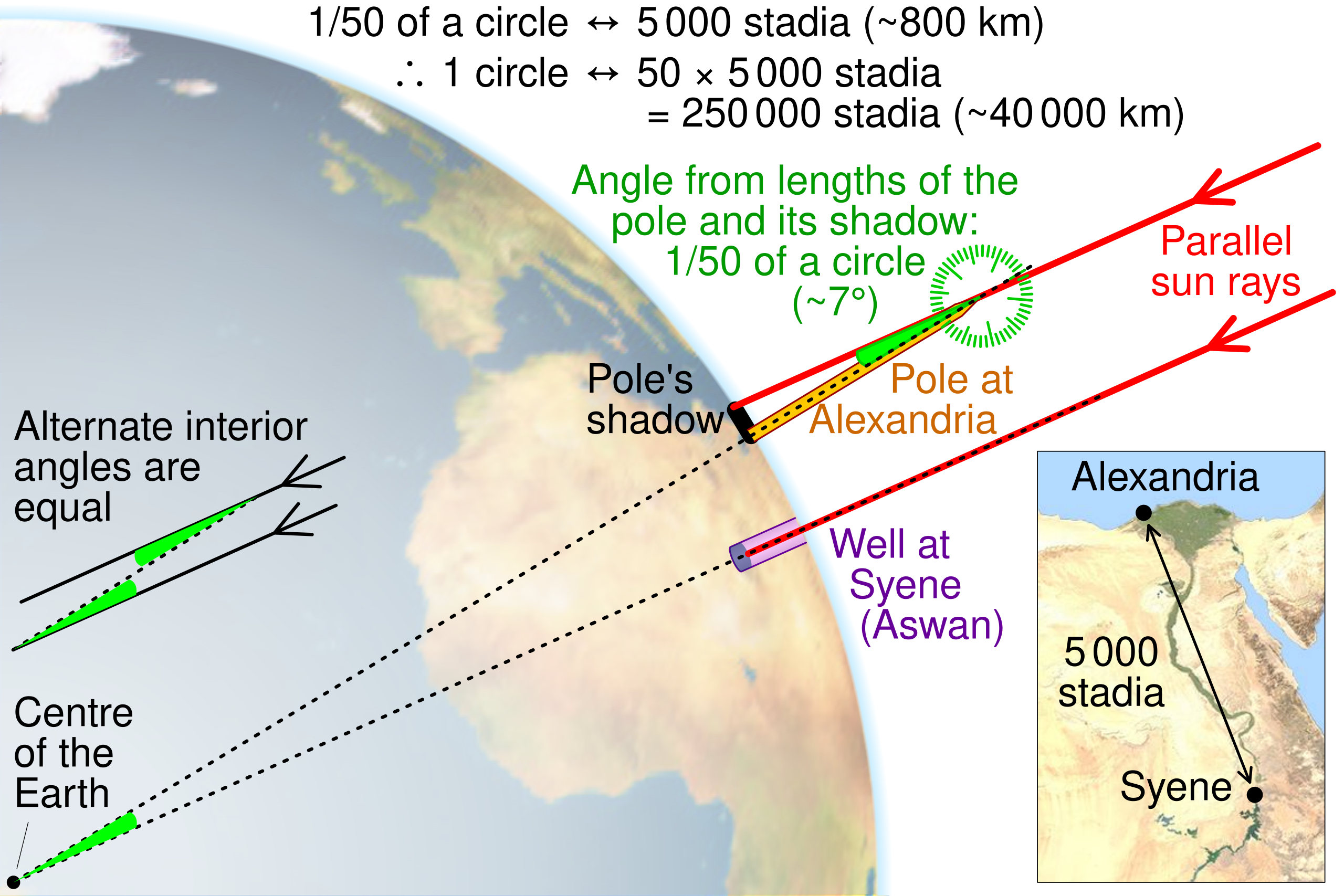
English: Illustration of the method Eratosthenes used to calculate the circumference of the Earth by CMG Lee. The map and globe are derived from http://commons.wikimedia.org/wiki/File:Egypt_sat.png and http://commons.wikimedia.org/wiki/File:Earth_orthographic_projection_Earthmap1000x500.jpg , respectively. |
||
| 日期 | |||
| 來源 |
|
||
| 作者 | cmglee, David Monniaux, jimht at shaw dot ca |


授權條款
此檔案採用創用CC 姓名標示-相同方式分享 4.0 國際授權條款。
- 您可以自由:
- 分享 – 複製、發佈和傳播本作品
- 重新修改 – 創作演繹作品
- 惟需遵照下列條件:
- 姓名標示 – 您必須指名出正確的製作者,和提供授權條款的連結,以及表示是否有對內容上做出變更。您可以用任何合理的方式來行動,但不得以任何方式表明授權條款是對您許可或是由您所使用。
- 相同方式分享 – 如果您利用本素材進行再混合、轉換或創作,您必須基於如同原先的相同或兼容的條款,來分布您的貢獻成品。
檔案歷史
點選日期/時間以檢視該時間的檔案版本。
| 日期/時間 | 縮圖 | 尺寸 | 使用者 | 備註 | |
|---|---|---|---|---|---|
| 目前 | 2023年2月15日 (三) 09:20 | | 512 × 341(54 KB) | Getsnoopy | Fixed some formatting issues. |
| 2022年6月28日 (二) 10:11 |  | 512 × 341(54 KB) | Andrei Stroe | File uploaded using svgtranslate tool (https://svgtranslate.toolforge.org/). Added translation for ro. | |
| 2019年10月9日 (三) 12:59 |  | 512 × 341(50 KB) | Cmglee | Explain how shadow angle maps to angle around Earth centre. | |
| 2016年11月1日 (二) 19:30 |  | 512 × 341(49 KB) | Cmglee | Use satellite photo instead of topo map, and add protractor. | |
| 2016年11月1日 (二) 00:34 |  | 512 × 341(48 KB) | Cmglee | Outline shapes to work around thumbnail rendering bug losing gradient. | |
| 2016年11月1日 (二) 00:26 |  | 512 × 341(49 KB) | Cmglee | User created page with UploadWizard |
檔案用途
下列頁面有用到此檔案:
全域檔案使用狀況
以下其他 wiki 使用了這個檔案:
- bs.wikipedia.org 的使用狀況
- ca.wikipedia.org 的使用狀況
- el.wikipedia.org 的使用狀況
- en.wikipedia.org 的使用狀況
- es.wikipedia.org 的使用狀況
- hi.wikipedia.org 的使用狀況
- hu.wikipedia.org 的使用狀況
- id.wikipedia.org 的使用狀況
- incubator.wikimedia.org 的使用狀況
- ja.wikipedia.org 的使用狀況
- ms.wikipedia.org 的使用狀況
- nl.wikipedia.org 的使用狀況
- pt.wikipedia.org 的使用狀況
- ro.wikipedia.org 的使用狀況
- sd.wikipedia.org 的使用狀況
- simple.wikipedia.org 的使用狀況
- sr.wikipedia.org 的使用狀況
- th.wikipedia.org 的使用狀況
- tr.wikipedia.org 的使用狀況
- uk.wikipedia.org 的使用狀況
- vi.wikipedia.org 的使用狀況