
File:Harz map.png

預覽大小:800 × 482 像素。 其他解析度:320 × 193 像素 | 640 × 385 像素 | 1,024 × 617 像素 | 1,280 × 771 像素 | 2,529 × 1,523 像素。
原始檔案 (2,529 × 1,523 像素,檔案大小:3.15 MB,MIME 類型:image/png)
摘要
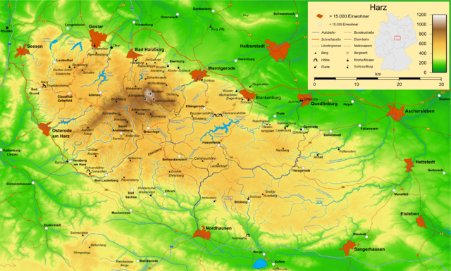
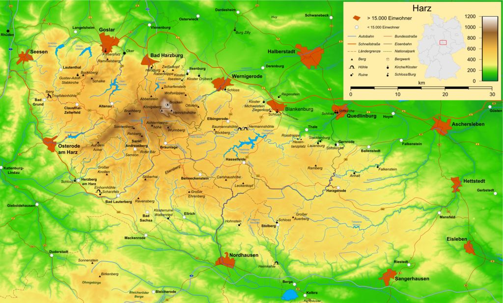
| 描述 | Map of the Harz mountains in Germany with mountains, rivers, lakes, reservoirs, all highways, all Bundesstraßen, Harzquerbahn, Brockenbahn, Selketalbahn, major towns and sights. |
| 日期 | |
| 來源 | 自己的作品 |
| 作者 | Bamse |
| 其他版本 |
Derivative works of this file: Karte Harzer Schmalspurbahnen.png  , ,  , ,  |
該地圖是使用通用製圖工具創建的: https://www.generic-mapping-tools.org/ 使用其中一個或多個公有領域浮雕數據集:
|

|
已授權您依據自由軟體基金會發行的無固定段落、封面文字和封底文字GNU自由文件授權條款1.2版或任意後續版本,對本檔進行複製、傳播和/或修改。該協議的副本列在GNU自由文件授權條款中。 |
| 此檔案採用創用CC 姓名標示-相同方式分享 3.0 未在地化版本授權條款。 | ||
| ||
| 已新增授權條款標題至此檔案,作為GFDL授權更新的一部份。 |

|
|
檔案歷史
點選日期/時間以檢視該時間的檔案版本。
| 日期/時間 | 縮圖 | 尺寸 | 使用者 | 備註 | |
|---|---|---|---|---|---|
| 目前 | 2009年12月15日 (二) 16:05 | | 2,529 × 1,523(3.15 MB) | Bamse | update, B6n is completed |
| 2007年12月14日 (五) 06:12 |  | 2,529 × 1,523(3.15 MB) | Bamse | {{Information |Description=Map of the Harz mountains in Germany with mountains, rivers, lakes, reservoirs, all highways, all Bundesstraßen, Harzquerbahn, Brockenbahn, [[:w:Selketalba | |
| 2007年9月19日 (三) 05:10 |  | 2,529 × 1,523(3.14 MB) | Bamse | ||
| 2007年9月19日 (三) 02:33 |  | 2,529 × 1,523(3.13 MB) | Bamse | {{Information |Description=Map of the w:Harz mountains in Germany. |Source=self-made |Date=19-09-2007 |Author= Bamse }} {{GFDL-GMT}} | |
| 2007年9月5日 (三) 08:21 |  | 2,529 × 1,523(3.09 MB) | Bamse | {{Information |Description=Map of the w:Harz mountains in Germany. |Source=self-made |Date=05-09-2007 |Author= Bamse }} {{GFDL-GMT}} | |
| 2007年7月25日 (三) 06:02 |  | 2,532 × 1,527(3 MB) | Bamse | {{Information |Description=Map of the w:Harz mountains in Germany. |Source=self-made |Date=25-07-2007 |Author= Bamse }} {{GFDL-GMT}} | |
| 2007年7月17日 (二) 10:30 |  | 2,529 × 1,526(2.94 MB) | Bamse | {{Information |Description=Map of the w:Harz mountains in Germany. |Source=self-made |Date=17-07-2007 |Author= Bamse }} {{GFDL-GMT}} | |
| 2007年7月11日 (三) 11:42 |  | 2,529 × 1,523(2.89 MB) | Bamse | {{Information |Description=Map of the w:Harz mountains in Germany. |Source=self-made |Date=11-07-2007 |Author= Bamse }} {{GFDL-GMT}} | |
| 2007年7月6日 (五) 10:21 |  | 2,529 × 1,523(2.84 MB) | Bamse | {{Information |Description=Map of the w:Harz mountains in Germany. |Source=self-made |Date=06-07-2007 |Author= Bamse }} {{GFDL-GMT}} | |
| 2007年6月28日 (四) 02:48 |  | 2,529 × 1,523(2.77 MB) | Bamse | {{Information |Description=Map of the w:Harz mountains in Germany. |Source=self-made |Date=28-06-2007 |Author= Bamse }} {{GFDL-GMT}} |
檔案用途
下列頁面有用到此檔案:
全域檔案使用狀況
以下其他 wiki 使用了這個檔案:
- ar.wikipedia.org 的使用狀況
- be.wikipedia.org 的使用狀況
- bg.wikipedia.org 的使用狀況
- br.wikipedia.org 的使用狀況
- ca.wikipedia.org 的使用狀況
- de.wikipedia.org 的使用狀況
- Harz (Mittelgebirge)
- Harzer Hexenstieg
- Kaiserweg (Harz)
- Karstwanderweg
- Wikipedia:Kartenwerkstatt/Archiv/2007-09
- Liste von Bergen im Harz
- Wikipedia:Kandidaten für exzellente Bilder/Archiv2007/14
- Harzklippen
- Selketalstieg
- Benutzer:Ulflulfl/Karten
- Harzer Baudensteig
- Harzer Försterstieg
- Unterharzer Teich- und Grabensystem
- Portal:Harz
- Bode-Selke-Stieg
- Oberharzer Erzgänge
- Vorlage:Navigationsleiste Regionale Wanderwege im Harz
- Harzer Grenzweg
- Liste der Moore im Harz
- Harzer Klosterwanderweg
- Kaiser-Otto-Höhenweg
- Georgi Wladimirowitsch Iwanow
- Steinway Trail
- Teufelsstieg
- Gebietstausch 1945 im Harz
- Portal:Harz/Eingangstext
- Benutzer:D.W.Germann/Liste von Poststempeln im Harz
- Benutzer:D.W.Germann/Liste der Brockenkarten
- Benutzer:D.W.Germann/Eigenes/Mediensammlung
- Benutzer:D.W.Germann/Liste der Kartenwerke des Harzes
- en.wikipedia.org 的使用狀況
- eo.wikipedia.org 的使用狀況
- fi.wikipedia.org 的使用狀況
- fr.wikipedia.org 的使用狀況
- fr.wiktionary.org 的使用狀況
- hu.wikipedia.org 的使用狀況
- incubator.wikimedia.org 的使用狀況
- is.wikipedia.org 的使用狀況
- it.wikipedia.org 的使用狀況
檢視此檔案的更多全域使用狀況。