
File:Heteralocha acutirostris distribution.png
預覽大小:451 × 600 像素。 其他解析度:180 × 240 像素 | 361 × 480 像素 | 577 × 768 像素 | 1,070 × 1,423 像素。
原始檔案 (1,070 × 1,423 像素,檔案大小:135 KB,MIME 類型:image/png)
摘要
| 描述 |
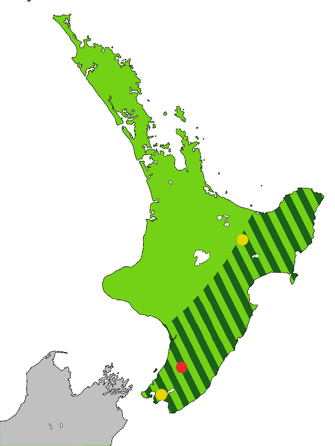
English: Light green: Range of the Huia, Heteralocha acutirostris, before the arrival of humans to New Zealand, as indicated by fossils. Dark green stripes: Range at 1840. Last sightings of the Huia: Red - last confirmed sighting in 1907 in Tararua Range. Yellow x 2 include one behind Eastbourne at the southern end of the North Island, and one in the Te Urewera National Park. The Huia is an extinct bird that was endemic to the North Island of New Zealand
Čeština: Laločník ostrozobý – distribuce. Světle zeleně: původní rozšíření laločníka ostrozobého; tmavě zelenými pruhy: rozsah druhu kolem roku 1840; červený bod: poslední potvrzené pozorování; žlutý bod: neověřená pozorování |
| 日期 | |
| 來源 | 自己的作品. Based on first version by Casliber with information provided by User:Kotare, using as a base for the outline File:New Zealand location map transparent.svg adapted by uploader User:Kahuroa |
| 作者 | Kahuroa |
授權條款
| 此作品已由其作者,Kahuroa,釋出至公有領域。此授權條款在全世界均適用。 這可能在某些國家不合法,如果是的話: |
檔案歷史
點選日期/時間以檢視該時間的檔案版本。
| 日期/時間 | 縮圖 | 尺寸 | 使用者 | 備註 | |
|---|---|---|---|---|---|
| 目前 | 2010年9月14日 (二) 18:36 | | 1,070 × 1,423(135 KB) | Kahuroa | Use new outline source: File:New Zealand location map transparent.svg adapted by uploader User:Kahuroa |
| 2010年8月31日 (二) 07:31 |  | 1,760 × 2,346(220 KB) | Kahuroa | New map - uses stripes to denote range in 1840 | |
| 2010年7月21日 (三) 21:46 |  | 449 × 599(49 KB) | Casliber | {{Information |Description= |Source={{own}} |Date= |Author= Casliber |Permission= |other_versions= }} | |
| 2010年7月21日 (三) 21:04 |  | 449 × 599(49 KB) | Casliber | {{Information |Description= Map added last sitings of the Huia. Red - last confirmed siting in 1907 in Tararua Range. Yellow x 2 include one behind Eastbourne, and one in the Te Urewera National Park. |Source={{own}} |Date= 23rd July 2010 |Author= [[User: | |
| 2010年7月21日 (三) 20:52 |  | 449 × 599(48 KB) | Casliber | {{Information |Description={{en|1=Map of deforestation of North Island on New Zealand}} |Source={{own}} |Author=Casliber |Date=22nd July 2010 |Permission=yes |other_versions=no }} Category:Maps |
檔案用途
下列頁面有用到此檔案:
全域檔案使用狀況
以下其他 wiki 使用了這個檔案:
- ar.wikipedia.org 的使用狀況
- bn.wikipedia.org 的使用狀況
- ca.wikipedia.org 的使用狀況
- ceb.wikipedia.org 的使用狀況
- cs.wikipedia.org 的使用狀況
- en.wikipedia.org 的使用狀況
- es.wikipedia.org 的使用狀況
- eu.wikipedia.org 的使用狀況
- fa.wikipedia.org 的使用狀況
- gl.wikipedia.org 的使用狀況
- he.wikipedia.org 的使用狀況
- hu.wikipedia.org 的使用狀況
- id.wikipedia.org 的使用狀況
- it.wikipedia.org 的使用狀況
- nn.wikipedia.org 的使用狀況
- pl.wikipedia.org 的使用狀況
- pt.wikipedia.org 的使用狀況
- ru.wikipedia.org 的使用狀況
- sr.wikipedia.org 的使用狀況
- sv.wikipedia.org 的使用狀況
- ta.wikipedia.org 的使用狀況
- uk.wikipedia.org 的使用狀況
- vi.wikipedia.org 的使用狀況
- www.wikidata.org 的使用狀況