
File:ISS021-E-15710 Pearl Harbor, Hawaii.jpg

預覽大小:800 × 531 像素。 其他解析度:320 × 213 像素 | 640 × 425 像素 | 1,024 × 680 像素 | 1,280 × 850 像素 | 2,560 × 1,700 像素 | 4,288 × 2,848 像素。
原始檔案 (4,288 × 2,848 像素,檔案大小:11.07 MB,MIME 類型:image/jpeg)
摘要
| 描述 |
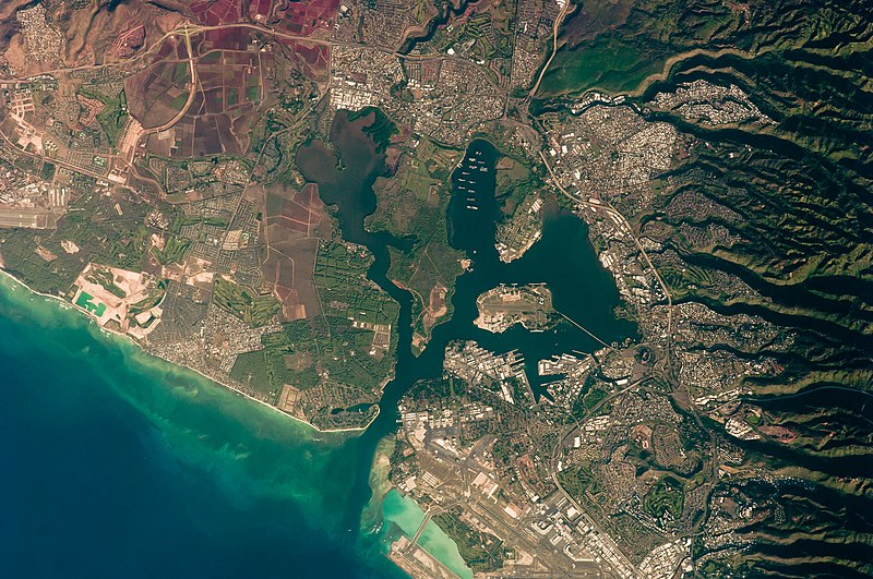
English: This detailed astronaut photograph illustrates the southern coastline of the Hawaiian island Oahu, including Pearl Harbor. On December 7, 1941—68 years ago—a surprise attack by the Japanese Navy on Pearl Harbor and other targets on the island of Oahu precipitated the entry of the United States into World War II. Today, Pearl Harbor is still in use as a major United States Navy installation, and along with Honolulu, it is one of the most heavily developed parts of the island.
A comparison between this image and a 2003 astronaut photograph of Pearl Harbor suggests that little observable land use or land cover change has occurred in the area over the past six years. The most significant difference is the presence of more naval vessels in the Reserve Fleet anchorage in Middle Loch (image center). The urban areas of Waipahu, Pearl City, and Aliamanu border the harbor to the northwest, north, and east. The built-up areas, recognizable by linear streets and white rooftops, contrast sharply with the reddish volcanic soils and green vegetation on the surrounding hills.
|
||||||||||||||||||||||||||||||||||||||||||||||||||
| 日期 | |||||||||||||||||||||||||||||||||||||||||||||||||||
| 來源 | http://eol.jsc.nasa.gov/scripts/sseop/photo.pl?mission=ISS021&roll=E&frame=15710 | ||||||||||||||||||||||||||||||||||||||||||||||||||
| 作者 |
|
||||||||||||||||||||||||||||||||||||||||||||||||||
| 其他版本 |
|
||||||||||||||||||||||||||||||||||||||||||||||||||

| 拍攝地點 | | 位於此地的本圖片與其他圖片: OpenStreetMap |
|---|
| 目標地點 | | 位於此地的本圖片與其他圖片: OpenStreetMap |
|---|
本圖像或影音收錄於美國國家航空暨太空總署 (NASA)休士頓太空中心(Johnson Space Center),其照片編號為: ISS021-E-15710 此標籤不表示文件的著作權狀態。任何文件在附有此標籤的同時還需要一個有效的著作權標籤。請參閱許可協議說明頁面以了解更多資訊。 其他語言:
|
授權條款
| 本作品由NASA創作,屬於公有領域。根據NASA的版權政策:“NASA的創作除非另有聲明否則不受版權保護。”(參見:Template:PD-USGov/zh,NASA版權政策或JPL圖像使用政策) | ||
 |
警告:
|
| 註解 | 該圖片含有註解:在維基媒體共享資源上查看註解 |
檔案歷史
點選日期/時間以檢視該時間的檔案版本。
| 日期/時間 | 縮圖 | 尺寸 | 使用者 | 備註 | |
|---|---|---|---|---|---|
| 目前 | 2013年3月22日 (五) 17:34 | | 4,288 × 2,848(11.07 MB) | Julian Herzog | User created page with UploadWizard |
檔案用途
下列頁面有用到此檔案:
全域檔案使用狀況
以下其他 wiki 使用了這個檔案:
- bn.wikipedia.org 的使用狀況
- ca.wikipedia.org 的使用狀況
- de.wikipedia.org 的使用狀況
- en.wikipedia.org 的使用狀況
- en.wikiversity.org 的使用狀況
- es.wikipedia.org 的使用狀況
- fr.wikipedia.org 的使用狀況
- fy.wikipedia.org 的使用狀況
- gn.wikipedia.org 的使用狀況
- oc.wikipedia.org 的使用狀況
- pt.wikipedia.org 的使用狀況