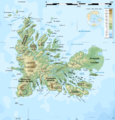
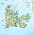
File:Kerguelen topographic map-fr.png
外觀

預覽大小:576 × 599 像素。 其他解析度:231 × 240 像素 | 461 × 480 像素 | 738 × 768 像素 | 984 × 1,024 像素 | 1,840 × 1,915 像素。
原始檔案 (1,840 × 1,915 像素,檔案大小:2.08 MB,MIME 類型:image/png)
檔案歷史
點選日期/時間以檢視該時間的檔案版本。
| 日期/時間 | 縮圖 | 尺寸 | 使用者 | 備註 | |
|---|---|---|---|---|---|
| 目前 | 2010年4月25日 (日) 14:13 |  | 1,840 × 1,915(2.08 MB) | Korrigan | Correcting roads after advice from B.navez |
| 2009年3月17日 (二) 21:02 |  | 1,840 × 1,915(2.08 MB) | Korrigan | Typo ("prequ'île") | |
| 2009年3月17日 (二) 19:45 |  | 1,840 × 1,915(2.08 MB) | Korrigan | {{Information |Description={{en|Topographic map of the Kerguelen Islands, Indian Ocean, France. Use the SVG version for translations and correcting mistakes.}} {{fr|Carte topographique des îles Kerguelen. Utilis |
檔案用途
沒有使用此檔案的頁面。
全域檔案使用狀況
以下其他 wiki 使用了這個檔案:
- avk.wikipedia.org 的使用狀況
- az.wikipedia.org 的使用狀況
- br.wikipedia.org 的使用狀況
- ca.wikipedia.org 的使用狀況
- ceb.wikipedia.org 的使用狀況
- cs.wikipedia.org 的使用狀況
- en.wikipedia.org 的使用狀況
- es.wikipedia.org 的使用狀況
- fr.wikipedia.org 的使用狀況
- Îles Kerguelen
- Presqu'île de la Société de géographie
- Mont Jullemier
- Port-aux-Français
- Mont Ross
- Glacier Cook
- Île Foch
- Île de Croÿ
- Îles de Boynes
- Presqu'île Ronarc'h
- Péninsule Courbet
- Île du Port (îles Kerguelen)
- Grande Terre (îles Kerguelen)
- Île du Roland
- Golfe du Morbihan (îles Kerguelen)
- Île Howe
- Île Saint-Lanne Gramont
- Île Longue (îles Kerguelen)
- Port-Couvreux
- Baie d'Audierne (îles Kerguelen)
- Golfe des Baleiniers
- Île Australia
- Île Haute
- Île Altazin
- Île Gaby
- Île de l'Ouest
- Baie de la Désolation
- Baie Rocheuse
- Baie du Noroît
- Baie Bretonne
- Baie Larose
- Baie des Swains
- Baie Sauvage
- Îles Leygues
- Péninsule Rallier du Baty
- Péninsule Gallieni
- Péninsule Loranchet
檢視此檔案的更多全域使用狀況。


