
File:Mars MOLA Topography by Fabio Crameri.png
預覽大小:800 × 564 像素。 其他解析度:320 × 226 像素 | 640 × 451 像素 | 1,024 × 722 像素 | 1,280 × 902 像素 | 2,481 × 1,749 像素。
原始檔案 (2,481 × 1,749 像素,檔案大小:10.19 MB,MIME 類型:image/png)
摘要
| 描述 |
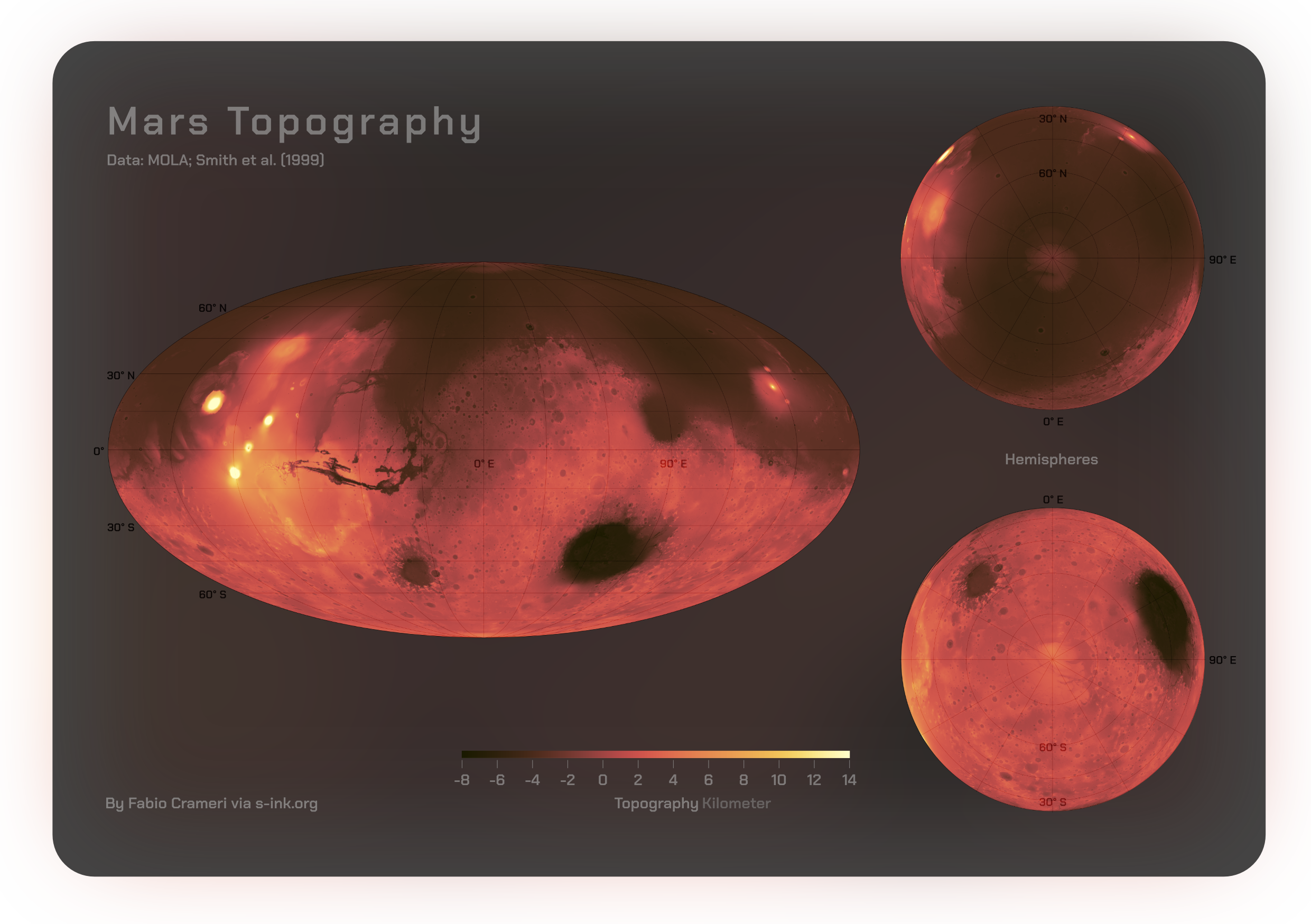
English: Comprehensive global maps by Fabio Crameri shared openly via https://s-ink.org/mars-topography-poster depicting the topography of the Martian surface, featuring polar regions. Represented is the digital elevation model (accessible at https://astrogeology.usgs.gov), derived from Mars Orbiter Laser Altimeter (MOLA) data collected by NASA’s Mars Global Surveyor (MGS) spacecraft (Albee et al., 2001; Smith and Zuber, 1999). The ‘lajolla‘ Scientific color map (see www.fabiocrameri.ch/colourmaps) is used to guarantee precise and color-blind-friendly representation of the data. |
| 日期 | |
| 來源 | 自己的作品 |
| 作者 | FCrameri |
授權條款
我,本作品的著作權持有者,決定用以下授權條款發佈本作品:
此檔案採用創用CC 姓名標示-相同方式分享 4.0 國際授權條款。
- 您可以自由:
- 分享 – 複製、發佈和傳播本作品
- 重新修改 – 創作演繹作品
- 惟需遵照下列條件:
- 姓名標示 – 您必須指名出正確的製作者,和提供授權條款的連結,以及表示是否有對內容上做出變更。您可以用任何合理的方式來行動,但不得以任何方式表明授權條款是對您許可或是由您所使用。
- 相同方式分享 – 如果您利用本素材進行再混合、轉換或創作,您必須基於如同原先的相同或兼容的條款,來分布您的貢獻成品。
檔案歷史
點選日期/時間以檢視該時間的檔案版本。
| 日期/時間 | 縮圖 | 尺寸 | 使用者 | 備註 | |
|---|---|---|---|---|---|
| 目前 | 2023年11月20日 (一) 14:50 | | 2,481 × 1,749(10.19 MB) | FCrameri | Uploaded own work with UploadWizard |
檔案用途
下列頁面有用到此檔案:
全域檔案使用狀況
以下其他 wiki 使用了這個檔案:
- en.wikipedia.org 的使用狀況