
File:Mawar 2023-05-26 0405Z.jpg

預覽大小:462 × 599 像素。 其他解析度:185 × 240 像素 | 370 × 480 像素 | 592 × 768 像素 | 789 × 1,024 像素 | 1,579 × 2,048 像素 | 3,700 × 4,800 像素。
原始檔案 (3,700 × 4,800 像素,檔案大小:12.01 MB,MIME 類型:image/jpeg)
摘要
| 描述 |
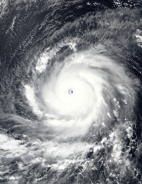
English: This true-color image of Typhoon Mawar (later known as "Betty" in the Philippines) over the Philippine Sea was captured on the afternoon of May 26, 2023, at 04:05 UTC, by the Visible Infrared Imaging Radiometer Suite (VIIRS) instrument flying aboard NOAA's Suomi-NPP satellite. Mawar was an extremely powerful typhoon that affected parts of the Indo-Pacific, particularly Guam, the Mariana Islands, the Philippines, and Taiwan, and the Southern Japanese Islands. The fourth depression, the second named storm (officially), the first typhoon, and the first violent typhoon of the 2023 West Pacific typhoon season. It originated from a tropical disturbance near Micronesia in mid-May 2023, where it began its track in a northwestward direction through the Mariana Islands and toward Guam. On May 24, Mawar passed by Guam, causing at least $4.3 billion (2023) in damage to the Island Territory. Mawar has contributed to six causalities in total two in Guam, one in Taiwan, one in the Philippines, and two in Japan. When this image was taken, Mawar was at its secondary and most intense peak intensity and moving west toward the Philippine Islands. The intensity of the typhoon when this image was taken was winds of 210 km/h (130 mph) (115 knots) on the 10-min Japan Meteorological Agency typhoon scale, making it a "Violent typhoon" on the scale, and according to the Joint Typhoon Warning Center, it had 1-min sustained winds of 295 km/h (185 mph) (160 knots) making it equivalent to an extremely powerful "Category 5 major hurricane," on the Saffir-Simpson Hurricane Wind Scale the fifth to reach that intensity during the year so far. The official minimum central pressure (provided by the JMA) was 900 mbar (26.6 inHg) and its unofficial minimum pressure (provided by the JTWC) was 897 mbar (26.5 inHg), this makes Mawar one of the most intense typhoons to occur in May in the Western Pacific basin, and so far the most intense globally during the current calendar year tied with Typhoon Bolaven in October. |
| 日期 | |
| 來源 | EOSDIS Worldview |
| 作者 | VIIRS imagery from NOAA's Suomi-NPP Satellite |
授權條款
本圖像屬於公有領域,因該作品最初來自於美國國家海洋和大氣管理局職員的職務作品。
|
檔案歷史
點選日期/時間以檢視該時間的檔案版本。
| 日期/時間 | 縮圖 | 尺寸 | 使用者 | 備註 | |
|---|---|---|---|---|---|
| 目前 | 2023年5月26日 (五) 21:16 | | 3,700 × 4,800(12.01 MB) | TheWxResearcher | Tweaked Brightness |
| 2023年5月26日 (五) 21:00 |  | 3,700 × 4,800(11.1 MB) | TheWxResearcher | Uploaded a work by VIIRS imagery from NOAA's Suomi-NPP Satellite from [https://worldview.earthdata.nasa.gov/ EOSDIS Worldview] with UploadWizard |
檔案用途
下列2個頁面有用到此檔案:
全域檔案使用狀況
以下其他 wiki 使用了這個檔案:
- en.wikipedia.org 的使用狀況
- es.wikipedia.org 的使用狀況
- ja.wikipedia.org 的使用狀況
- ko.wikipedia.org 的使用狀況
- pt.wikipedia.org 的使用狀況
- th.wikipedia.org 的使用狀況
- tl.wikipedia.org 的使用狀況
- uk.wikipedia.org 的使用狀況
- www.wikidata.org 的使用狀況