
File:Mweru-Luapula.jpg
預覽大小:250 × 599 像素。 其他解析度:100 × 240 像素 | 396 × 949 像素。
原始檔案 (396 × 949 像素,檔案大小:79 KB,MIME 類型:image/jpeg)
摘要
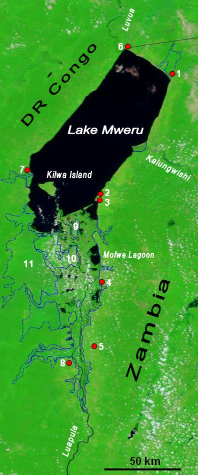
| 描述 | The lower Luapula River, its delta where it enters Lake Mweru, and Mweru's outlet, the Luvua River going on north to the Lualaba and Congo rivers. Water shows up as black in this false-colour NASA satellite image. The extent of the Luapula Swamps is shown by the solid blue line, and the extent of the floodplain is shown as a dotted line. The towns are, in Zambia: 1 Chiengi, 2 Kashikishi, 3 Nchelenge, 4 Mwansabombwe, 5 Mwense; in DR Congo: 6 Pweto, 7 Kilwa, 8 Kasenga. Other features: 9 Chisenga Island, 10 the largest swamp island (in DR Congo), 11 the main floodplain. |
| 日期 | |
| 來源 | Image NASA Visible Earth website, overlay in Word |
| 作者 | NASA credit Jacques Descloitres, MODIS Rapid Response Team, NASA/GSFC; overlay by User:Rexparry_sydney |
| 授權許可 (重用此檔案) |
NASA public domain and my permission for overlay to also be Public Domain. |
授權條款
| 本作品由NASA創作,屬於公有領域。根據NASA的版權政策:“NASA的創作除非另有聲明否則不受版權保護。”(參見:Template:PD-USGov/zh,NASA版權政策或JPL圖像使用政策) | ||
 |
警告:
|
檔案歷史
點選日期/時間以檢視該時間的檔案版本。
| 日期/時間 | 縮圖 | 尺寸 | 使用者 | 備註 | |
|---|---|---|---|---|---|
| 目前 | 2007年3月28日 (三) 03:51 | | 396 × 949(79 KB) | Rexparry sydney~commonswiki | {{Information |Description=The lower Luapula River, its delta where is enters Lake Mweru, and Mweru's outlet, the Luvua River going on north to the Lualaba and Congo rivers. Water shows up as black in this false-colour NASA satellite image. The extent of |
檔案用途
全域檔案使用狀況
以下其他 wiki 使用了這個檔案:
- af.wikipedia.org 的使用狀況
- ar.wikipedia.org 的使用狀況
- bg.wikipedia.org 的使用狀況
- ca.wikipedia.org 的使用狀況
- ceb.wikipedia.org 的使用狀況
- da.wikipedia.org 的使用狀況
- de.wikipedia.org 的使用狀況
- en.wikipedia.org 的使用狀況
- es.wikipedia.org 的使用狀況
- fa.wikipedia.org 的使用狀況
- ff.wikipedia.org 的使用狀況
- ha.wikipedia.org 的使用狀況
- hu.wikipedia.org 的使用狀況
- incubator.wikimedia.org 的使用狀況
- it.wikipedia.org 的使用狀況
- ka.wikipedia.org 的使用狀況
- nl.wikipedia.org 的使用狀況
- no.wikipedia.org 的使用狀況
- pl.wikipedia.org 的使用狀況
- ru.wikipedia.org 的使用狀況
- rw.wikipedia.org 的使用狀況
- simple.wikipedia.org 的使用狀況
- sr.wikipedia.org 的使用狀況
- sv.wikipedia.org 的使用狀況
- sw.wikipedia.org 的使用狀況
- www.wikidata.org 的使用狀況