
File:Nazi-Soviet 1941.png
此為最大尺寸。
Nazi-Soviet_1941.png (372 × 460 像素,檔案大小:78 KB,MIME 類型:image/png)

|
本圖片是以PNG、GIF或JPEG格式上傳。然而,其中包含的資料或訊息,應該重新建立成可縮放向量圖形(SVG)檔案,以更有效率或更準確的方式儲存。如有可能,請上傳本圖片的SVG格式版本。在上傳之後,請修改維基各姊妹計畫中所有使用舊版圖片的條目(列在圖像連結章節中),替換為新版圖片,並在舊圖片的描述頁中加入{{Vector version available|新圖片名稱.svg}}模板,同時移除本模板。
|
摘要
| 描述 |
English: From the original en.wikipedia page:
|
| 日期 | 2009年3月9日 (原始上傳日期) |
| 來源 | Transferred from en.wikipedia to Commons by Trần Nguyễn Minh Huy. |
| 作者 | 原上傳者為英文維基百科的Mosedschurte |
| 其他版本 | Second World War Europe 05 1941 east fr.svg |
授權條款

|
已授權您依據自由軟體基金會發行的無固定段落、封面文字和封底文字GNU自由文件授權條款1.2版或任意後續版本,對本檔進行複製、傳播和/或修改。該協議的副本列在GNU自由文件授權條款中。 |
| 此檔案採用創用CC 姓名標示-相同方式分享 3.0 未在地化版本授權條款。 | ||
| ||
| 已新增授權條款標題至此檔案,作為GFDL授權更新的一部份。 |

|
免責聲明 本圖像(或其中包含的符號)在以下國家受法律所禁止,原因是有關符號(以各種方式)表現共產主義、社會主義或類似的政體;或與其相關的政黨/組織:格魯吉亞、拉脫維亞、立陶宛(由憲法法庭通過的行政違法法典第18818條)、烏克蘭(刑法第436-1條)、匈牙利(2012年刑法C章第335節)和印度尼西亞。 |

|
免責聲明 這張圖像呈現(或用來代表)納粹黨、其相關組織或其他被德國聯邦憲法法院所禁止的組織使用過的徽章和符號。 在內文使用這些已被查禁組織的徽章(例如納粹黨卐字或箭十字)也會違反奧地利、匈牙利、波蘭、捷克、法國、巴西、以色列、烏克蘭和俄羅斯等國家的法律。在德國刑法典(StGB)第86a條和波蘭刑法第256條(Dz.U. 1997 nr 88 poz. 553)內有明文規定。 |
原始上傳日誌
The original description page was here. All following user names refer to en.wikipedia.
- 2009-03-09 17:05 Mosedschurte 372×460× (79594 bytes) ===English=== * Description: Second world war map on June 1941 * Source: Own map, based on the maps of the [http://www.lib.utexas.edu/maps/ University of Texas Libraries] * Author: [[User:Mosedschurte|Mosedschurte]], February 12, 2009 ===License=== {{GFD
- 2009-02-18 18:26 Mosedschurte 385×479× (64782 bytes) ===English=== * Description: Second world war map on June 1941 * Source: Own map, based on the maps of the [http://www.lib.utexas.edu/maps/ University of Texas Libraries] * Author: [[User:Mosedschurte|Mosedschurte]], February 12, 2009 ===License=== {{GFD
- 2009-02-18 07:13 Mosedschurte 377×447× (62398 bytes) ===English=== * Description: Second world war map on June 1941 * Source: Own map, based on the maps of the [http://www.lib.utexas.edu/maps/ University of Texas Libraries] * Author: [[User:Mosedschurte|Mosedschurte]], February 12, 2009 ===License=== {{GFD
- 2009-02-12 12:54 Mosedschurte 398×468× (64310 bytes) ===English=== * Description: Second world war map on June 1941 * Source: Own map, based on the maps of the [http://www.lib.utexas.edu/maps/ University of Texas Libraries] * Author: [[User:Mosedschurte|Mosedschurte]], February 12, 2009 ===License=== {{GFD
- 2009-02-12 12:50 Mosedschurte 383×463× (63199 bytes) ===English=== * Description: Second world war map on June 1941 * Source: Own map, based on the maps of the [http://www.lib.utexas.edu/maps/ University of Texas Libraries] * Author: [[User:Mosedschurte|Mosedschurte]], February 12, 2009 ===License=== {{GFD
檔案歷史
點選日期/時間以檢視該時間的檔案版本。
| 日期/時間 | 縮圖 | 尺寸 | 使用者 | 備註 | |
|---|---|---|---|---|---|
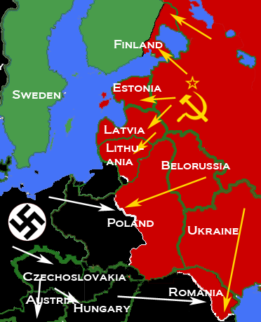
| 目前 | 2010年4月5日 (一) 09:26 | | 372 × 460(78 KB) | Trần Nguyễn Minh Huy | {{Information |Description={{en|* Description: Map depicting most of Central and Eastern Europe, showing 1938 borders, along with Axis (black) and Soviet (red) military and political advances until late 1940. * Source: Own map, based on the maps of the [h |
檔案用途
下列頁面有用到此檔案:
全域檔案使用狀況
以下其他 wiki 使用了這個檔案:
- ar.wikipedia.org 的使用狀況
- bn.wikipedia.org 的使用狀況
- bs.wikipedia.org 的使用狀況
- de.wikipedia.org 的使用狀況
- el.wikipedia.org 的使用狀況
- en.wikipedia.org 的使用狀況
- es.wikipedia.org 的使用狀況
- fr.wikipedia.org 的使用狀況
- hr.wikipedia.org 的使用狀況
- id.wikipedia.org 的使用狀況
- lv.wikipedia.org 的使用狀況
- pl.wikipedia.org 的使用狀況
- pt.wikipedia.org 的使用狀況
- ro.wikipedia.org 的使用狀況
- sr.wikipedia.org 的使用狀況
- tl.wikipedia.org 的使用狀況
- uk.wikipedia.org 的使用狀況
- vi.wikipedia.org 的使用狀況
- www.wikidata.org 的使用狀況