
File:Operation 1027.svg

此 SVG 檔案的 PNG 預覽的大小:500 × 376 像素。 其他解析度:319 × 240 像素 | 638 × 480 像素 | 1,021 × 768 像素 | 1,280 × 963 像素 | 2,560 × 1,925 像素。
原始檔案 (SVG 檔案,表面大小:500 × 376 像素,檔案大小:1.64 MB)
摘要

|
This file may be updated to reflect new information. If you wish to use a specific version of the file without new updates being mirrored, please upload the required version as a separate file. |
本vector image使用Inkscape創作。
| 描述 |
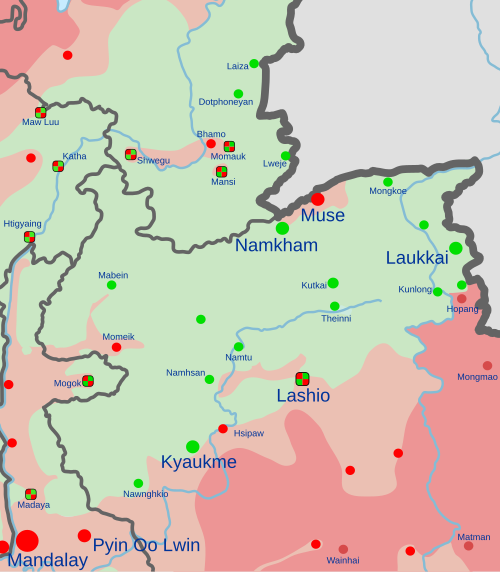
English: Map of Operation 1027.
and allies
In the respective colours: |
||
| 日期 | (first version) | ||
| 來源 |
自己的作品, derived from ACLED data and en:Template:Myanmar Civil War detailed map.
|
||
| 作者 | Clyde H. Mapping |
授權條款
我,本作品的著作權持有者,決定用以下授權條款發佈本作品:
此檔案採用創用CC 姓名標示-相同方式分享 4.0 國際授權條款。
- 您可以自由:
- 分享 – 複製、發佈和傳播本作品
- 重新修改 – 創作演繹作品
- 惟需遵照下列條件:
- 姓名標示 – 您必須指名出正確的製作者,和提供授權條款的連結,以及表示是否有對內容上做出變更。您可以用任何合理的方式來行動,但不得以任何方式表明授權條款是對您許可或是由您所使用。
- 相同方式分享 – 如果您利用本素材進行再混合、轉換或創作,您必須基於如同原先的相同或兼容的條款,來分布您的貢獻成品。
檔案歷史
點選日期/時間以檢視該時間的檔案版本。
| 日期/時間 | 縮圖 | 尺寸 | 使用者 | 備註 | |
|---|---|---|---|---|---|
| 目前 | 2024年3月19日 (二) 13:59 | | 500 × 376(1.64 MB) | Clyde H. Mapping | Per talk page |
| 2024年3月7日 (四) 22:19 |  | 500 × 376(1.64 MB) | Clyde H. Mapping | Updated per template | |
| 2024年1月9日 (二) 02:00 |  | 500 × 376(1.65 MB) | Clyde H. Mapping | Updated Kutkai, Hsenwi, Kyaukme, Momeik, and Kalewa per template | |
| 2024年1月5日 (五) 21:34 |  | 500 × 376(1.65 MB) | Clyde H. Mapping | Updated Laukkai and Hopang per template | |
| 2024年1月4日 (四) 03:56 |  | 500 × 376(1.65 MB) | Clyde H. Mapping | Major update based on new source (Template:Myanmar Civil War detailed map) | |
| 2023年12月15日 (五) 12:04 |  | 500 × 376(1.5 MB) | Clyde H. Mapping | Corrected Laukkai location, added Konkyan | |
| 2023年11月18日 (六) 03:10 |  | 500 × 376(1.49 MB) | Clyde H. Mapping | Improved pattern for contested areas | |
| 2023年11月16日 (四) 12:09 |  | 500 × 376(1.48 MB) | Clyde H. Mapping | Updated rebel presence (TBA, KIA) in Shan and Sagaing | |
| 2023年11月12日 (日) 22:17 |  | 500 × 376(1.48 MB) | Clyde H. Mapping | Added Hsipaw | |
| 2023年11月9日 (四) 04:09 |  | 500 × 376(1.47 MB) | Clyde H. Mapping | Corrected Hseni and Kunlong |
檔案用途
下列2個頁面有用到此檔案:
全域檔案使用狀況
以下其他 wiki 使用了這個檔案:
- en.wikipedia.org 的使用狀況
- fa.wikipedia.org 的使用狀況
- fr.wikipedia.org 的使用狀況
- ko.wikipedia.org 的使用狀況
- mnw.wikipedia.org 的使用狀況
- ms.wikipedia.org 的使用狀況
- my.wikipedia.org 的使用狀況
- ru.wikipedia.org 的使用狀況
- uk.wikipedia.org 的使用狀況
- vi.wikipedia.org 的使用狀況