
File:PIA16202-MarsCuriosityRover-TowardGlenelg-Panorama-20121001.jpg

預覽大小:800 × 152 像素。 其他解析度:320 × 61 像素 | 640 × 122 像素 | 1,024 × 195 像素 | 1,280 × 243 像素 | 7,824 × 1,488 像素。
原始檔案 (7,824 × 1,488 像素,檔案大小:1.05 MB,MIME 類型:image/jpeg)
摘要
| 描述 |
English: 10.04.2012
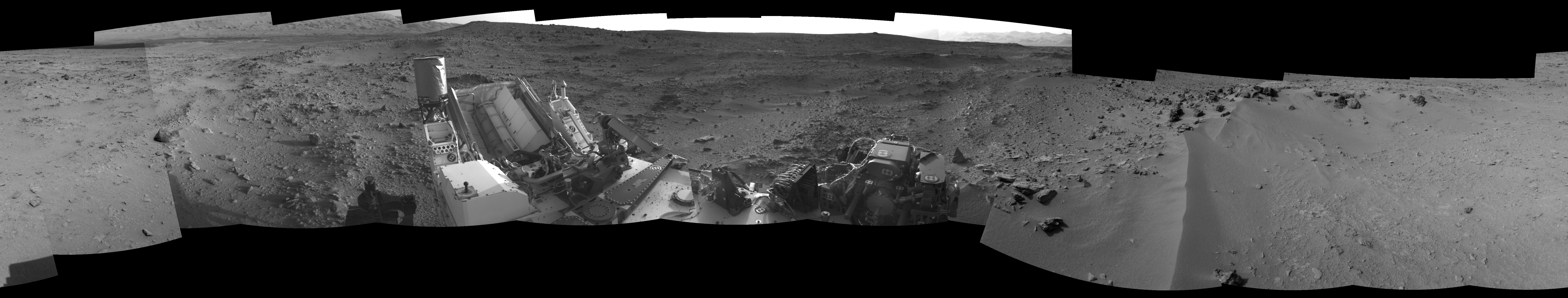
View on the Way to 'Glenelg' This 360-degree panorama from NASA's Mars rover Curiosity shows the rocky terrain surrounding it as of its 55th Martian day, or sol, of the mission (Oct. 1, 2012). The base of Mount Sharp can be seen at upper left. The sandy area seen to the right is a region called "Rocknest," which is the current candidate for Curiosity's first scooping experiments on Mars. This image was taken by the rover's Navigation camera. Image Credit: NASA/JPL-Caltech |
| 日期 | |
| 來源 | http://photojournal.jpl.nasa.gov/jpeg/PIA16202.jpg |
| 作者 | NASA/JPL-Caltech |
| 其他版本 | http://photojournal.jpl.nasa.gov/catalog/PIA16202 |
授權條款
| 本作品由NASA創作,屬於公有領域。根據NASA的版權政策:“NASA的創作除非另有聲明否則不受版權保護。”(參見:Template:PD-USGov/zh,NASA版權政策或JPL圖像使用政策) | ||
 |
警告:
|
檔案歷史
點選日期/時間以檢視該時間的檔案版本。
| 日期/時間 | 縮圖 | 尺寸 | 使用者 | 備註 | |
|---|---|---|---|---|---|
| 目前 | 2012年10月5日 (五) 16:59 | 7,824 × 1,488(1.05 MB) | Drbogdan | User created page with UploadWizard |
檔案用途
全域檔案使用狀況
以下其他 wiki 使用了這個檔案:
- lb.wikipedia.org 的使用狀況
- ru.wikipedia.org 的使用狀況