
File:PIA19693-Pluto-Charon-2Sides-20150627.jpg

原始檔案 (1,920 × 1,080 像素,檔案大小:265 KB,MIME 類型:image/jpeg)
摘要
| 描述 |
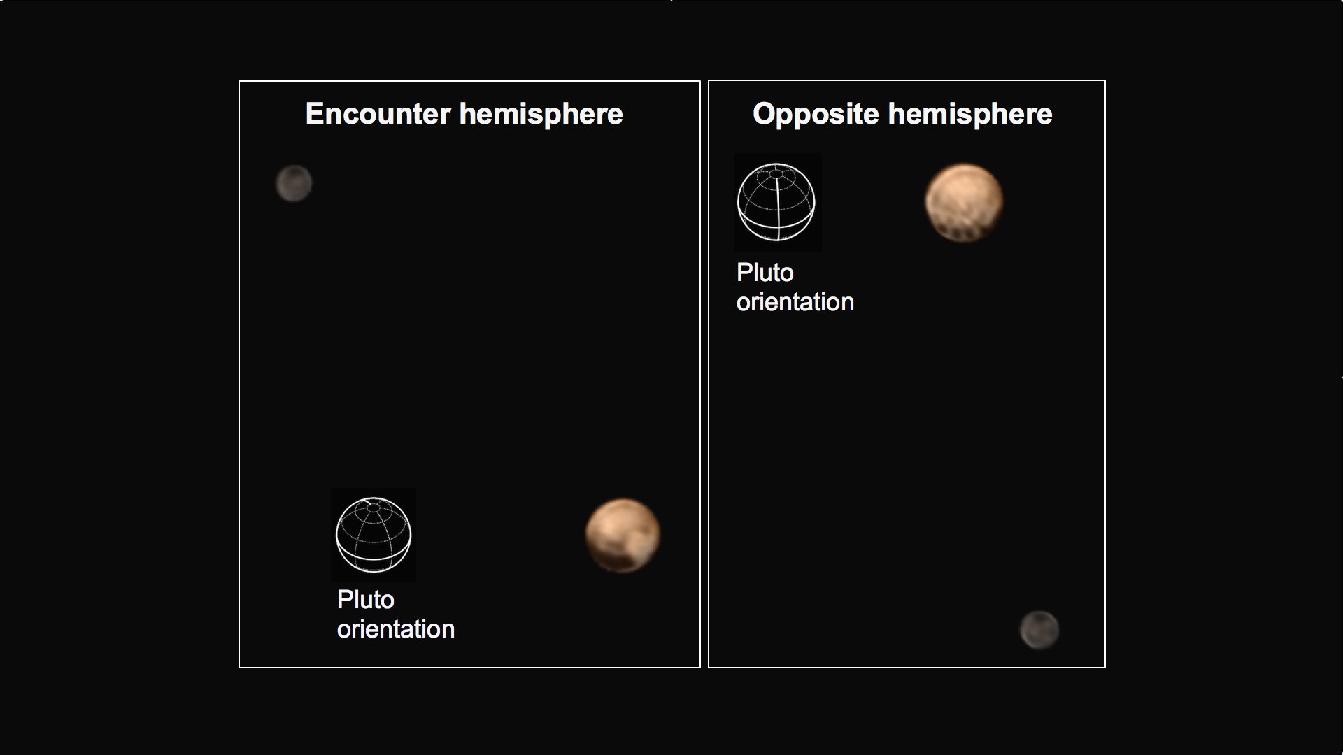
English: PIA19693: Two Faces of Pluto
http://photojournal.jpl.nasa.gov/catalog/PIA19693 This pair of approximately true color images of Pluto and its big moon Charon, taken by NASA's New Horizons spacecraft, highlight the dramatically different appearance of different sides of the dwarf planet, and reveal never-before-seen details on Pluto's varied surface. The views were made by combining high-resolution black-and-white images from the Long Range Reconnaissance Imager (LORRI) with color information from the lower-resolution color camera that is part of the Ralph instrument. The left-hand image shows the side of Pluto that always faces away from Charon -- this is the side that will be seen at highest resolution by New Horizons when it makes its close approach to Pluto on July 14th. This hemisphere is dominated by a very dark region that extends along the equator and is redder than its surroundings, alongside a strikingly bright, paler-colored region which straddles the equator on the right-hand side of the disk. The opposite hemisphere, the side that faces Charon, is seen in the right-hand image. The most dramatic feature on this side of Pluto is a row of dark dots arranged along the equator. The origin of all these features is still mysterious, but may be revealed in the much more detailed images that will be obtained as the spacecraft continues its approach to Pluto. In both images, Charon shows a darker and grayer color than Pluto, and a conspicuous dark polar region. The left-hand image was obtained at 5:37 UT on June 25th 2015, at a distance from Pluto of 22.9 million kilometers (14.3 million miles) and has a central longitude of 152 degrees. The right-hand image was obtained at 23:15 UT on June 27th 2015, at a distance from Pluto of 19.7 million kilometers (12.2 million miles) with a central longitude of 358 degrees. Insets show the orientation of Pluto in each image -- the solid lines mark the equator and the prime meridian, which is defined to be the longitude that always faces Charon. The smallest visible features are about 200 km (120 miles) across. The Johns Hopkins University Applied Physics Laboratory in Laurel, Maryland, designed, built, and operates the New Horizons spacecraft, and manages the mission for NASA's Science Mission Directorate. The Southwest Research Institute, based in San Antonio, leads the science team, payload operations and encounter science planning. New Horizons is part of the New Frontiers Program managed by NASA's Marshall Space Flight Center in Huntsville, Alabama. |
| 日期 | |
| 來源 | http://photojournal.jpl.nasa.gov/figures/PIA19693_fig1.jpg |
| 作者 | NASA/Johns Hopkins University Applied Physics Laboratory/Southwest Research Institute |
授權條款
| 本作品由NASA創作,屬於公有領域。根據NASA的版權政策:“NASA的創作除非另有聲明否則不受版權保護。”(參見:Template:PD-USGov/zh,NASA版權政策或JPL圖像使用政策) | ||
 |
警告:
|
檔案歷史
點選日期/時間以檢視該時間的檔案版本。
| 日期/時間 | 縮圖 | 尺寸 | 使用者 | 備註 | |
|---|---|---|---|---|---|
| 目前 | 2015年7月3日 (五) 02:25 | | 1,920 × 1,080(265 KB) | Drbogdan | User created page with UploadWizard |
檔案用途
下列2個頁面有用到此檔案:
全域檔案使用狀況
以下其他 wiki 使用了這個檔案:
- fa.wikipedia.org 的使用狀況
- hi.wikipedia.org 的使用狀況
- id.wikipedia.org 的使用狀況
- ja.wikipedia.org 的使用狀況
- pnb.wikipedia.org 的使用狀況
- sr.wikipedia.org 的使用狀況
- ur.wikipedia.org 的使用狀況