
File:Paris Metro Ligne 1.svg

此 SVG 檔案的 PNG 預覽的大小:512 × 197 像素。 其他解析度:320 × 123 像素 | 640 × 246 像素 | 1,024 × 394 像素 | 1,280 × 493 像素 | 2,560 × 985 像素。
原始檔案 (SVG 檔案,表面大小:512 × 197 像素,檔案大小:13 KB)
摘要
| 描述 |
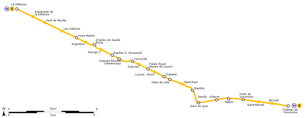
English: Geographically accurate path of Paris Métro Line 1. Français : Plan géographique de la ligne 1 du métro de Paris. |
||
| 日期 | (UTC) | ||
| 來源 | File:Ligne 1.gif by Metropolitan under licence Public Domain | ||
| 作者 | Sémhur (留言) | ||
| 其他版本 | |||
| SVG | 本vector image使用Inkscape創作 。
|
||
| Graphic Lab |

| 目標地點 | | 位於此地的本圖片與其他圖片: OpenStreetMap |
|---|
授權條款
我,本作品的著作權持有者,決定用以下授權條款發佈本作品:
| 此檔案在創用CC CC0 1.0 通用公有領域貢獻宣告之下分發。 | |
| 在此宣告之下分發本作品者,已依據各國著作權法,在全世界放棄其對本作品所擁有的著作權及所有相關相似的法律權利,從而將本作品貢獻至公有領域。您可以複製、修改、分發和演示該作品,用於任何商業用途,所有這些都不需要請求授權。
|
檔案歷史
點選日期/時間以檢視該時間的檔案版本。
| 日期/時間 | 縮圖 | 尺寸 | 使用者 | 備註 | |
|---|---|---|---|---|---|
| 目前 | 2020年7月17日 (五) 17:53 | 512 × 197(13 KB) | Teo.raff | Metro and line icons and colours update | |
| 2018年10月12日 (五) 23:21 | 2,166 × 834(40 KB) | AlexBurn44 | corres | ||
| 2015年3月13日 (五) 12:14 | 2,166 × 834(41 KB) | Sémhur | REmove black line | ||
| 2014年12月28日 (日) 16:47 | 2,166 × 834(37 KB) | Sémhur | == {{int:filedesc}} == {{Information |Description={{Multilingual description |en= Geographically accurate path of en:Paris Métro Line 1. |fr= Plan géographique de la fr:ligne 1 du métro de Paris. }} |Source=File:Ligne 1.gif by [[:en... |
檔案用途
下列頁面有用到此檔案:
全域檔案使用狀況
以下其他 wiki 使用了這個檔案:
- bs.wikipedia.org 的使用狀況
- cs.wikipedia.org 的使用狀況
- dsb.wikipedia.org 的使用狀況
- en.wikipedia.org 的使用狀況
- eo.wikipedia.org 的使用狀況
- es.wikipedia.org 的使用狀況
- fr.wikipedia.org 的使用狀況
- it.wikipedia.org 的使用狀況
- ja.wikipedia.org 的使用狀況
- ko.wikipedia.org 的使用狀況
- lb.wikipedia.org 的使用狀況
- nl.wikipedia.org 的使用狀況
- no.wikipedia.org 的使用狀況
- oc.wikipedia.org 的使用狀況
- pl.wikipedia.org 的使用狀況
- ru.wikipedia.org 的使用狀況
- sk.wikipedia.org 的使用狀況
- tr.wikipedia.org 的使用狀況
- uk.wikipedia.org 的使用狀況
- zh-min-nan.wikipedia.org 的使用狀況