
File:Pedra Branca Map.svg

此 SVG 檔案的 PNG 預覽的大小:800 × 487 像素。 其他解析度:320 × 195 像素 | 640 × 390 像素 | 1,024 × 624 像素 | 1,280 × 779 像素 | 2,560 × 1,559 像素 | 3,478 × 2,118 像素。
原始檔案 (SVG 檔案,表面大小:3,478 × 2,118 像素,檔案大小:230 KB)
摘要
| 描述 |
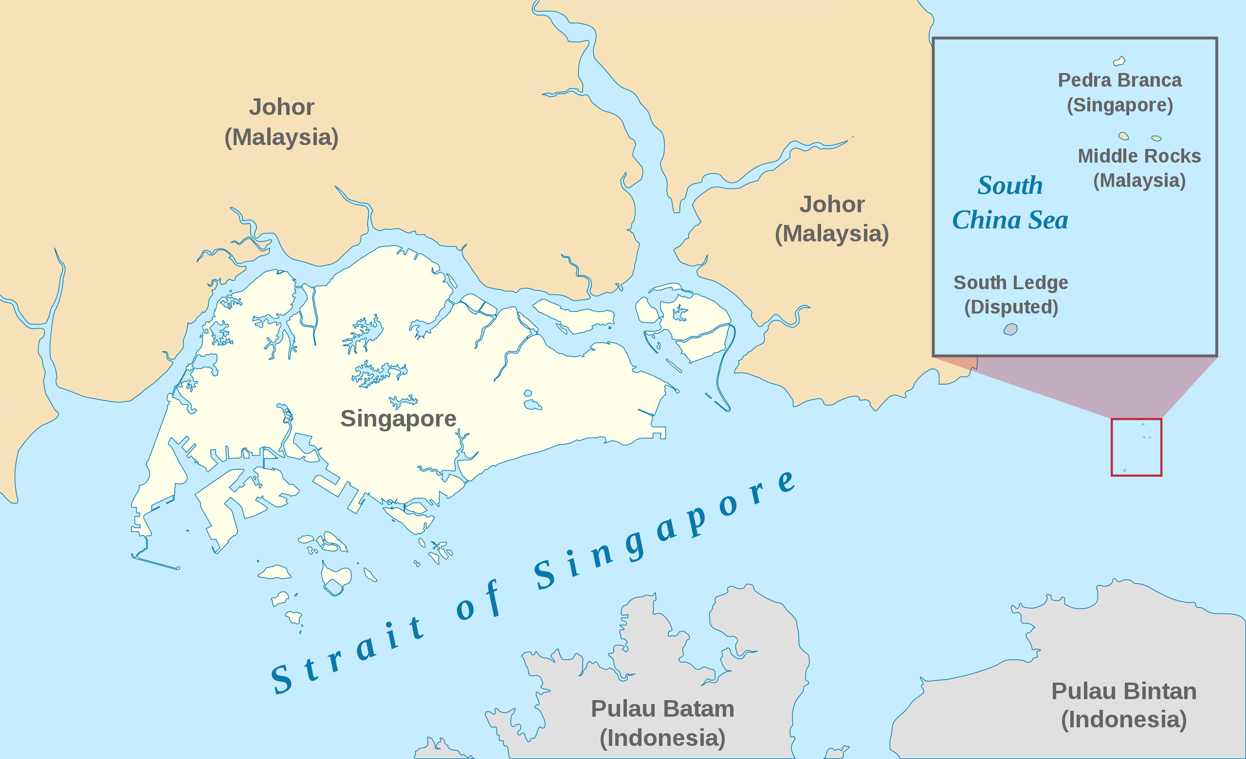
English: A map showing the approximate location of the island of Pedra Branca, which is under the sovereignty of Singapore, at the eastern end of the Singapore Strait where it meets the South China Sea. Near it are the maritime features Middle Rocks (under Malaysian sovereignty) and South Ledge, and the coasts of Johor, Malaysia, and Bintan, Indonesia. |
| 日期 | |
| 來源 | Self-made, modified from Image:Singapore Outline.svg. |
| 作者 | Jappalang. |
| 授權許可 (重用此檔案) |
PD-Self. |
本vector image使用Inkscape創作 .
授權條款
| 我,此作品的版權所有人,釋出此作品至公共領域。此授權條款在全世界均適用。 這可能在某些國家不合法,如果是的話: 我授予任何人有權利使用此作品於任何用途,除受法律約束外,不受任何限制。 |
檔案歷史
點選日期/時間以檢視該時間的檔案版本。
| 日期/時間 | 縮圖 | 尺寸 | 使用者 | 備註 | |
|---|---|---|---|---|---|
| 目前 | 2021年1月13日 (三) 06:27 | | 3,478 × 2,118(230 KB) | Seloloving | recoloured to Wikipedia map colour style |
| 2020年2月9日 (日) 09:59 |  | 3,478 × 2,118(219 KB) | *angys* | File uploaded using svgtranslate tool (https://tools.wmflabs.org/svgtranslate/). Added translation for zh. | |
| 2017年10月22日 (日) 14:36 |  | 3,478 × 2,118(208 KB) | Seloloving | Fixed spelling error with "Enlargement" | |
| 2017年10月22日 (日) 14:34 |  | 3,478 × 2,118(208 KB) | Seloloving | Recolored claimant states to a more neutral colour. Shifted the Insert Map further up and added note to clarify its actual location. Changed fonts and colours to align with Wikipedia Map guidelines. | |
| 2014年5月24日 (六) 19:42 |  | 3,261 × 1,986(194 KB) | Seloloving | Fixed text rendering. Fixed map. | |
| 2014年5月4日 (日) 05:36 |  | 3,261 × 1,986(276 KB) | Seloloving | Fixed Johor's shape. | |
| 2014年5月4日 (日) 05:24 |  | 3,261 × 1,986(274 KB) | Seloloving | Fixed font problems. | |
| 2014年5月4日 (日) 05:20 |  | 3,261 × 1,986(273 KB) | Seloloving | Fixed problems. | |
| 2014年5月4日 (日) 05:12 |  | 3,261 × 1,986(282 KB) | Seloloving | Fixed geography of the islands. | |
| 2008年9月30日 (二) 04:05 |  | 3,261 × 1,986(396 KB) | Jappalang | "South Lodge" corrected to "South Ledge" |
檔案用途
下列2個頁面有用到此檔案:
全域檔案使用狀況
以下其他 wiki 使用了這個檔案:
- de.wikipedia.org 的使用狀況
- en.wikipedia.org 的使用狀況
- es.wikipedia.org 的使用狀況
- fr.wikipedia.org 的使用狀況
- he.wikipedia.org 的使用狀況
- id.wikipedia.org 的使用狀況
- it.wikipedia.org 的使用狀況
- ja.wikipedia.org 的使用狀況
- ko.wikipedia.org 的使用狀況
- mdf.wikipedia.org 的使用狀況
- ms.wikipedia.org 的使用狀況
- pt.wikipedia.org 的使用狀況
- ru.wikipedia.org 的使用狀況
- ta.wikipedia.org 的使用狀況
- th.wikipedia.org 的使用狀況
- vi.wikipedia.org 的使用狀況