
File:Rodrigues Island topographic map-fr.png
預覽大小:637 × 600 像素。 其他解析度:255 × 240 像素 | 510 × 480 像素 | 816 × 768 像素 | 1,088 × 1,024 像素 | 1,700 × 1,600 像素。
原始檔案 (1,700 × 1,600 像素,檔案大小:874 KB,MIME 類型:image/png)
摘要
| 拍攝地點 | | 位於此地的本圖片與其他圖片: OpenStreetMap |
|---|
| 描述 |
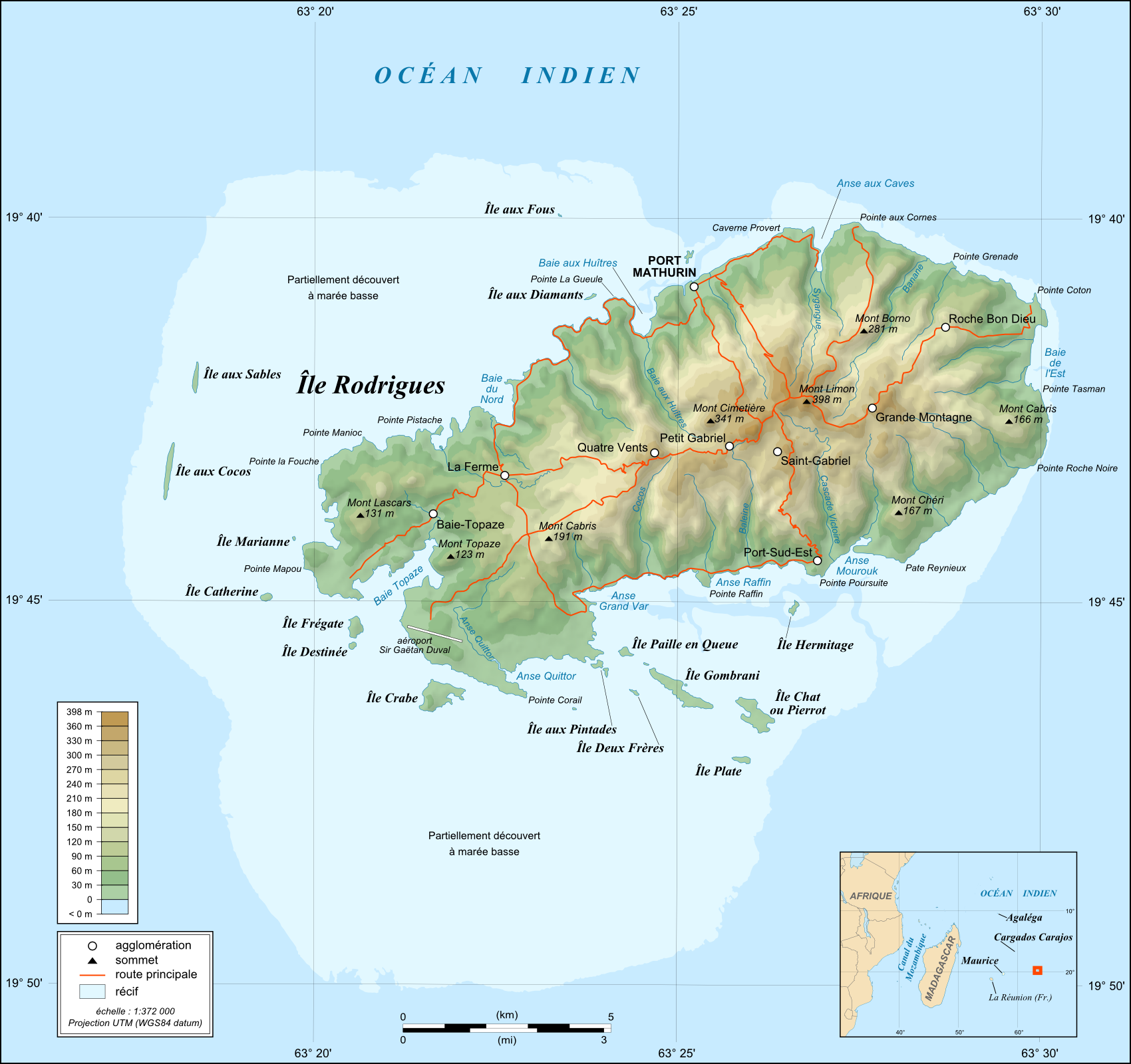
English: Topographic map in French of Rodrigues Island, Mauritius
Note : for translation purpose, use the SVG version Scale : 1:372,000 (accuracy : about 93 m) ; Printing size : 7.79 x 7.33 cm Français : Carte topographique en français de l'île de Rodrigues, Maurice
Échelle : 1:372 000 (précision : environ 93 m) ; Taille d'impression : 7,79 x 7,33 cm UTM projection, WGS84 datum
|
||
| 日期 | May 2008 (modified September 2008) | ||
| 來源 |
English: Own work (see complete description on Image:Rodrigues_Island_topographic_map-fr.svg).
Français : Création personnelle (voir description complète sur Image:Rodrigues_Island_topographic_map-fr.svg). |
||
| 作者 | Eric Gaba (Sting - fr:Sting) | ||
| 授權許可 (重用此檔案) |
|
||
| 其他版本 |
[]
|


授權條款
我,本作品的著作權持有者,決定用以下授權條款發佈本作品:

|
已授權您依據自由軟體基金會發行的無固定段落、封面文字和封底文字GNU自由文件授權條款1.2版或任意後續版本,對本檔進行複製、傳播和/或修改。該協議的副本列在GNU自由文件授權條款中。 |
This file is licensed under the Creative Commons Attribution-Share Alike 4.0 International, 3.0 Unported, 2.5 Generic, 2.0 Generic and 1.0 Generic license.
- 您可以自由:
- 分享 – 複製、發佈和傳播本作品
- 重新修改 – 創作演繹作品
- 惟需遵照下列條件:
- 姓名標示 – 您必須指名出正確的製作者,和提供授權條款的連結,以及表示是否有對內容上做出變更。您可以用任何合理的方式來行動,但不得以任何方式表明授權條款是對您許可或是由您所使用。
- 相同方式分享 – 如果您利用本素材進行再混合、轉換或創作,您必須基於如同原先的相同或兼容的條款,來分布您的貢獻成品。
您可以選擇您需要的授權條款。
檔案歷史
點選日期/時間以檢視該時間的檔案版本。
| 日期/時間 | 縮圖 | 尺寸 | 使用者 | 備註 | |
|---|---|---|---|---|---|
| 目前 | 2010年7月19日 (一) 13:41 | | 1,700 × 1,600(874 KB) | Sting | Color profile |
| 2008年9月6日 (六) 02:43 |  | 1,700 × 1,600(814 KB) | Sting | Adding roads and other labels ; new standard colors | |
| 2008年5月14日 (三) 03:55 |  | 1,700 × 1,600(706 KB) | Sting | == Summary == {{Location|19|43|00|S|63|25|00|E|scale:200000}} <br/> {{Information |Description={{en|Topographic map in French of Rodrigues Island, Mauritius<br/>''Note :'' for translation purpose, use the [[:Ro |
檔案用途
下列頁面有用到此檔案:
全域檔案使用狀況
以下其他 wiki 使用了這個檔案:
- de.wikipedia.org 的使用狀況
- es.wikipedia.org 的使用狀況
- fr.wikipedia.org 的使用狀況
- gl.wikipedia.org 的使用狀況
- mt.wikipedia.org 的使用狀況
- no.wikipedia.org 的使用狀況
- ro.wikipedia.org 的使用狀況
- sr.wikipedia.org 的使用狀況
- uk.wikipedia.org 的使用狀況