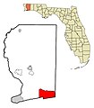
File:SantaRosaCountyFloridaMapNavarreHightlighted.jpg
外觀
SantaRosaCountyFloridaMapNavarreHightlighted.jpg (525 × 600 像素,檔案大小:46 KB,MIME 類型:image/jpeg)
檔案歷史
點選日期/時間以檢視該時間的檔案版本。
| 日期/時間 | 縮圖 | 尺寸 | 使用者 | 備註 | |
|---|---|---|---|---|---|
| 目前 | 2018年7月14日 (六) 23:49 |  | 525 × 600(46 KB) | Navarre0107 | One more alternation for the betterment of its accuracy. |
| 2018年7月14日 (六) 23:30 |  | 525 × 600(46 KB) | Navarre0107 | Updated, with slightly more accurate depiction of the borders of Navarre. | |
| 2017年12月4日 (一) 17:09 |  | 525 × 600(46 KB) | Navarre0107 | User created page with UploadWizard |
檔案用途
下列頁面有用到此檔案:
全域檔案使用狀況
以下其他 wiki 使用了這個檔案:
- azb.wikipedia.org 的使用狀況
- en.wikipedia.org 的使用狀況
- fa.wikipedia.org 的使用狀況
- fr.wikipedia.org 的使用狀況
- no.wikipedia.org 的使用狀況
- sco.wikipedia.org 的使用狀況
- tt.wikipedia.org 的使用狀況
- vo.wikipedia.org 的使用狀況
- www.wikidata.org 的使用狀況


