
File:Satellite image of Antigua And Barbuda in September 2002.jpg
此為最大尺寸。
Satellite_image_of_Antigua_And_Barbuda_in_September_2002.jpg (311 × 372 像素,檔案大小:16 KB,MIME 類型:image/jpeg)
摘要
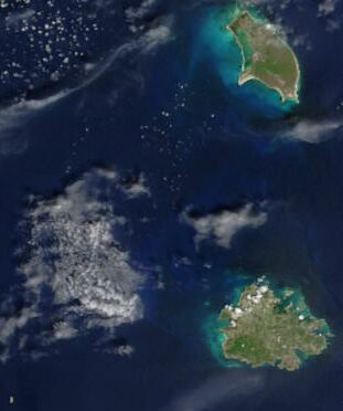
| 描述 | Cropped satellite image, showing the three islands of Antigua And Barbuda. |
| 日期 | |
| 來源 | Cropped from: http://visibleearth.nasa.gov/view_rec.php?id=4342 |
| 作者 | Jacques Descloitres, MODIS Rapid Response Team, NASA/GSFC |
授權條款
| 本作品由NASA創作,屬於公有領域。根據NASA的版權政策:“NASA的創作除非另有聲明否則不受版權保護。”(參見:Template:PD-USGov/zh,NASA版權政策或JPL圖像使用政策) | ||
 |
警告:
|
| 註解 | 該圖片含有註解:在維基媒體共享資源上查看註解 |
檔案歷史
點選日期/時間以檢視該時間的檔案版本。
| 日期/時間 | 縮圖 | 尺寸 | 使用者 | 備註 | |
|---|---|---|---|---|---|
| 目前 | 2004年12月18日 (六) 14:26 | | 311 × 372(16 KB) | Hautala | {{PD-USGov-NASA}} Cropped satellite image, showing the three islands of Antigua And Barbuda. Original image taken from NASA's Visible Earth http://visibleearth.nasa.gov/cgi-bin/viewrecord?21888 |
檔案用途
沒有使用此檔案的頁面。
全域檔案使用狀況
以下其他 wiki 使用了這個檔案:
- af.wikipedia.org 的使用狀況
- arz.wikipedia.org 的使用狀況
- ast.wikipedia.org 的使用狀況
- azb.wikipedia.org 的使用狀況
- ca.wikipedia.org 的使用狀況
- cy.wikipedia.org 的使用狀況
- de.wikivoyage.org 的使用狀況
- diq.wikipedia.org 的使用狀況
- el.wikipedia.org 的使用狀況
- en.wikipedia.org 的使用狀況
- eo.wikipedia.org 的使用狀況
- fa.wikipedia.org 的使用狀況
- fi.wikipedia.org 的使用狀況
- fr.wikipedia.org 的使用狀況
- ga.wikipedia.org 的使用狀況
- gd.wikipedia.org 的使用狀況
- gl.wikipedia.org 的使用狀況
- ha.wikipedia.org 的使用狀況
- hu.wikipedia.org 的使用狀況
- ia.wikipedia.org 的使用狀況
- io.wikipedia.org 的使用狀況
- ja.wikipedia.org 的使用狀況
- kab.wikipedia.org 的使用狀況
- nl.wikipedia.org 的使用狀況
- pcd.wikipedia.org 的使用狀況
- pl.wikipedia.org 的使用狀況
- pl.wiktionary.org 的使用狀況
- ps.wikipedia.org 的使用狀況
- ru.wikipedia.org 的使用狀況
- sq.wikipedia.org 的使用狀況
- uk.wikipedia.org 的使用狀況
- vec.wikipedia.org 的使用狀況
- www.wikidata.org 的使用狀況