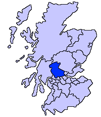
File:ScotlandStirling.png
外觀
ScotlandStirling.png (200 × 230 像素,檔案大小:3 KB,MIME 類型:image/png)
檔案歷史
點選日期/時間以檢視該時間的檔案版本。
| 日期/時間 | 縮圖 | 尺寸 | 使用者 | 備註 | |
|---|---|---|---|---|---|
| 目前 | 2009年2月22日 (日) 04:04 |  | 200 × 230(3 KB) | Mahahahaneapneap | Compressed |
| 2005年5月17日 (二) 21:44 |  | 200 × 230(4 KB) | Voyager | Stirling unitary council Slightly edited version of a map drawn by Morwen {{GFDL}} Category:Maps of Scottish unitary councils |
檔案用途
下列頁面有用到此檔案:
全域檔案使用狀況
以下其他 wiki 使用了這個檔案:
- be.wikipedia.org 的使用狀況
- bg.wikipedia.org 的使用狀況
- cs.wikipedia.org 的使用狀況
- cy.wikipedia.org 的使用狀況
- de.wikipedia.org 的使用狀況
- en.wikipedia.org 的使用狀況
- eo.wikipedia.org 的使用狀況
- eu.wikipedia.org 的使用狀況
- Stirling
- Stirling (eremu administratiboa)
- Lankide:Euskaldunaa
- Dunblane
- Txantiloi:Stirling
- Bannockburn
- Bridge of Allan
- Callander
- Doune
- Aberfoyle (Stirling)
- Balfron
- Balmaha
- Balquhidder
- Wikiproiektu:Irlanda, Gales eta Eskoziako udalerriak
- Blairlogie
- Blanefield
- Buchlyvie
- Cambusbarron
- Cambuskenneth
- Cowie (Stirling)
- Crianlarich
- Croftamie
- Deanston
- Drymen
- Fallin (Stirling)
- Fintry
- Gargunnock
- Gartmore
- Hillfoots Villages
- Killearn
- Killin
- Kinlochard
- Kippen
- Lochearnhead
- Milton of Buchanan
- Plean
- Port of Menteith
- Strathblane
- Strathyre
- Thornhill (Stirling)
- Tyndrum
檢視此檔案的更多全域使用狀況。


