
File:Scotland 1974 Administrative Map.png

預覽大小:345 × 600 像素。 其他解析度:138 × 240 像素 | 276 × 480 像素 | 442 × 768 像素 | 589 × 1,024 像素 | 2,000 × 3,476 像素。
原始檔案 (2,000 × 3,476 像素,檔案大小:1.42 MB,MIME 類型:image/png)
摘要
| 描述 |
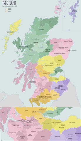
English: Administrative map of Scotland in 1974 showing the reforms of the Local Government Act (Scotland) 1973 |
| 日期 | |
| 來源 | 自己的作品 |
| 作者 | XrysD |
授權條款
我,本作品的著作權持有者,決定用以下授權條款發佈本作品:
此檔案採用創用CC 姓名標示-相同方式分享 3.0 未在地化版本授權條款。
- 您可以自由:
- 分享 – 複製、發佈和傳播本作品
- 重新修改 – 創作演繹作品
- 惟需遵照下列條件:
- 姓名標示 – 您必須指名出正確的製作者,和提供授權條款的連結,以及表示是否有對內容上做出變更。您可以用任何合理的方式來行動,但不得以任何方式表明授權條款是對您許可或是由您所使用。
- 相同方式分享 – 如果您利用本素材進行再混合、轉換或創作,您必須基於如同原先的相同或兼容的條款,來分布您的貢獻成品。
檔案歷史
點選日期/時間以檢視該時間的檔案版本。
| 日期/時間 | 縮圖 | 尺寸 | 使用者 | 備註 | |
|---|---|---|---|---|---|
| 目前 | 2020年7月19日 (日) 08:49 | | 2,000 × 3,476(1.42 MB) | XrysD | Fixed typos: Tweedale->Tweeddale, Kirkintuloch->Kirkintilloch, Eastward->Eastwood, Cunningham->Cunninghame |
| 2012年11月25日 (日) 10:04 |  | 2,000 × 3,475(1.55 MB) | XrysD | Corrected date. Added categories | |
| 2012年11月24日 (六) 10:03 |  | 2,000 × 3,475(1.55 MB) | XrysD | User created page with UploadWizard |
檔案用途
沒有使用此檔案的頁面。
全域檔案使用狀況
以下其他 wiki 使用了這個檔案:
- de.wikipedia.org 的使用狀況
- en.wikipedia.org 的使用狀況
- Angus, Scotland
- Clackmannanshire
- Fife
- East Lothian
- Dumfries and Galloway
- Midlothian
- Highland (council area)
- Scottish Borders
- Moray
- Argyll and Bute
- Inverclyde
- Lothian
- West Lothian
- Politics of Edinburgh
- Perth and Kinross
- Falkirk (council area)
- Lochaber
- Berwickshire
- Sutherland
- Ross and Cromarty
- Tayside
- Grampian
- Caithness
- Roxburghshire
- Strathclyde
- Stirling (council area)
- Cunninghame
- County of Nairn
- Tweeddale
- Ettrick and Lauderdale
- Annandale and Eskdale
- Nithsdale
- Stewartry
- North East Fife (district)
- Banff and Buchan
- Gordon (district)
- Kincardine and Deeside
- Badenoch and Strathspey
- Skye and Lochalsh
- Bearsden and Milngavie
- Cumbernauld and Kilsyth (district)
- Cumnock and Doon Valley
- Clydesdale (district)
- Eastwood, Strathclyde
- Kilmarnock and Loudoun (district)
- Kyle and Carrick
- Strathkelvin
- Local government areas of Scotland (1975–1996)
- Comhairle nan Eilean Siar
檢視此檔案的更多全域使用狀況。