
File:Slavonia01.png

預覽大小:709 × 600 像素。 其他解析度:284 × 240 像素 | 568 × 480 像素 | 797 × 674 像素。
原始檔案 (797 × 674 像素,檔案大小:80 KB,MIME 類型:image/png)
摘要
| 描述 |
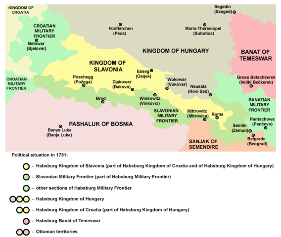
English: Kingdom of Slavonia in 1751.
Српски / srpski: Kraljevina Slavonija 1751. godine. |
| 日期 | 2006年12月28日 (原始上傳日期) |
| 來源 | 自己的作品 |
| 作者 | PANONIAN |
授權條款

|
This map has been uploaded by Electionworld from en.wikipedia.org to enable the |
historic map (self made by user:PANONIAN)
| 我,此作品的版權所有人,釋出此作品至公共領域。此授權條款在全世界均適用。 這可能在某些國家不合法,如果是的話: 我授予任何人有權利使用此作品於任何用途,除受法律約束外,不受任何限制。 |
References
- http://dullman.co.cc/images/habsburg-empire-13.jpg
- http://www.terra.es/personal7/jqvaraderey/181815ge.gif
- http://cro-eu.com/galerija-fotografija/albums/userpics/10001/1526_-_1882_Hrvatska_Vojna_Krajina.gif
- http://www.srpska-mreza.com/Krajina/map/krajina-map.jpg
- http://xxlworld.xx.ohost.de/povijest/prilozi/15-20/krajina/map_vojna_krajina.gif
- http://www.crohis.com/srkulj2/vojkraj.jpg
- http://www.zamolcanaistra.eu/slike/zemljevid17.jpg
- http://www.crohis.com/shisatlas3/vojkrajina.htm
- http://www.croatianviewpoint.com/Content-Folder/Maps/2map.jpg
- http://photos-f.ak.fbcdn.net/photos-ak-snc1/v1610/47/33/41683386895/n41683386895_1285164_9924.jpg
- The Times History of Europe, Times Books, 2002.
- Istorijski atlas, Zavod za udžbenike i nastavna sredstva - Zavod za kartografiju "Geokarta", Beograd, 1999.
- Školski istorijski atlas, Zavod za izdavanje udžbenika Socijalističke Republike Srbije, Beograd, 1970.
- Povijesni atlas, Učila - Zagreb, Zagreb, 1971.
檔案歷史
點選日期/時間以檢視該時間的檔案版本。
| 日期/時間 | 縮圖 | 尺寸 | 使用者 | 備註 | |
|---|---|---|---|---|---|
| 目前 | 2011年4月12日 (二) 14:15 | | 797 × 674(80 KB) | PANONIAN | minor improvement |
| 2011年4月11日 (一) 10:17 |  | 797 × 674(77 KB) | PANONIAN | improved version | |
| 2007年5月20日 (日) 19:25 |  | 726 × 519(19 KB) | Minestrone | Enhanced version | |
| 2006年12月28日 (四) 15:41 |  | 726 × 519(12 KB) | Electionworld | {{ew|en|PANONIAN}} historic map (self made) {{PD-self}} Category:Maps of the history of Croatia Category:Maps of the history of Vojvodina |
檔案用途
下列頁面有用到此檔案:
全域檔案使用狀況
以下其他 wiki 使用了這個檔案:
- an.wikipedia.org 的使用狀況
- be.wikipedia.org 的使用狀況
- ca.wikipedia.org 的使用狀況
- cs.wikipedia.org 的使用狀況
- de.wikipedia.org 的使用狀況
- el.wikipedia.org 的使用狀況
- en.wikipedia.org 的使用狀況
- es.wikipedia.org 的使用狀況
- et.wikipedia.org 的使用狀況
- eu.wikipedia.org 的使用狀況
- fr.wikipedia.org 的使用狀況
- he.wikipedia.org 的使用狀況
- hr.wikipedia.org 的使用狀況
- id.wikipedia.org 的使用狀況
- it.wikipedia.org 的使用狀況
- ja.wikipedia.org 的使用狀況
- ko.wikipedia.org 的使用狀況
- mk.wikipedia.org 的使用狀況
- nl.wikipedia.org 的使用狀況
- pl.wikipedia.org 的使用狀況
- pt.wikipedia.org 的使用狀況
- ru.wikipedia.org 的使用狀況
- sh.wikipedia.org 的使用狀況
- sk.wikipedia.org 的使用狀況
- sr.wikipedia.org 的使用狀況
- uk.wikipedia.org 的使用狀況
- www.wikidata.org 的使用狀況