
File:Spice Islands (Tanzania).svg

此 SVG 檔案的 PNG 預覽的大小:486 × 599 像素。 其他解析度:195 × 240 像素 | 389 × 480 像素 | 623 × 768 像素 | 831 × 1,024 像素 | 1,661 × 2,048 像素 | 713 × 879 像素。
原始檔案 (SVG 檔案,表面大小:713 × 879 像素,檔案大小:15 KB)
.svg?uselang=zh-tw)
.svg?uselang=zh-tw)
.svg?action=history&uselang=zh-tw)
.svg)
摘要
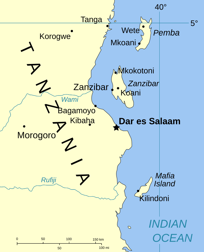
| 描述 | Part of the map of Tanzania, showing the Spice Islands. |
| 日期 | |
| 來源 | Vectors self-made in Inkscape. Source was cropped from http://www.lib.utexas.edu/maps/africa/tanzania_pol_2003.jpg which is said to be in the public domain in the Perry-Castañeda Map Collection FAQ. |
| 作者 | Mysid |
| 授權許可 (重用此檔案) |
PD |
| 其他版本 |
Image:Spice Islands (Zanzibar highlighted).svg in French : Image:Spice_Islands_Tanzania-fr.svg in French : Image:Spice_Islands-Zanzibar_highlighted-fr.svg |
.svg)
授權條款
| 我,此作品的版權所有人,釋出此作品至公共領域。此授權條款在全世界均適用。 這可能在某些國家不合法,如果是的話: 我授予任何人有權利使用此作品於任何用途,除受法律約束外,不受任何限制。 |
檔案歷史
點選日期/時間以檢視該時間的檔案版本。
| 日期/時間 | 縮圖 | 尺寸 | 使用者 | 備註 | |
|---|---|---|---|---|---|
| 目前 | 2007年1月6日 (六) 20:01 | | 713 × 879(15 KB) | Mysid | (a bit more) standard colors |
| 2006年5月29日 (一) 06:44 |  | 713 × 879(20 KB) | Mysid | corrected buggy scale | |
| 2006年5月29日 (一) 06:40 |  | 713 × 879(20 KB) | Mysid | New version, exported from CorelDraw (inkscape seems buggy) | |
| 2006年5月28日 (日) 18:23 |  | 713 × 893(37 KB) | Mysid | {{Information |Description=Part of the map of Tanzania, showing the Spice Islands. |Source=Vectors self-made in Inkscape. Source was cropped from http://www.lib.utexas.edu/maps/africa/tanzania_pol_2003.jpg which is said to be in the pu |
檔案用途
下列頁面有用到此檔案:
全域檔案使用狀況
以下其他 wiki 使用了這個檔案:
- ckb.wikipedia.org 的使用狀況
- da.wikipedia.org 的使用狀況
- eo.wikipedia.org 的使用狀況
- eu.wikipedia.org 的使用狀況
- fa.wikipedia.org 的使用狀況
- fo.wikipedia.org 的使用狀況
- fr.wikipedia.org 的使用狀況
- hr.wikipedia.org 的使用狀況
- it.wikipedia.org 的使用狀況
- ja.wikipedia.org 的使用狀況
- mi.wikipedia.org 的使用狀況
- nl.wikipedia.org 的使用狀況
- no.wikipedia.org 的使用狀況
- pt.wikipedia.org 的使用狀況
- sr.wikipedia.org 的使用狀況
- sv.wikipedia.org 的使用狀況
- vi.wikipedia.org 的使用狀況
.svg)