
File:Texel.jpg
此為最大尺寸。
Texel.jpg (800 × 600 像素,檔案大小:44 KB,MIME 類型:image/jpeg)
摘要
| 描述 |
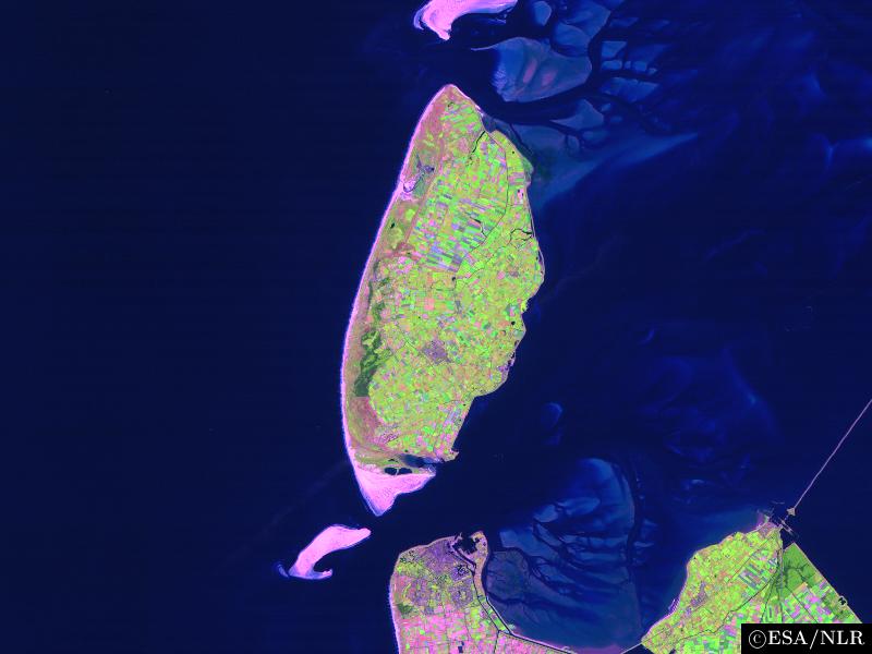
en:False colour en:satellite en:image of the en:island of en:Texel and its surroundings. The image was made by NLR and ESA.NLR and ESA are cited as its source. To the south of the island, part of the en:mainland of the Dutch en:province of en:North Holland can be seen, including the en:city of en:Den Helder (bottom center) and the former island of en:Wieringen (bottom right). Further features include the sand bar of en:Noorderhaaks to the southwest of Texel; the southernmost part of the neighbouring island of en:Vlieland (top center); the en:Afsluitdijk en:dam, which connects North Holland to en:Friesland (center right), the en:Wadden Sea, east of Texel; and the en:North Sea (west of Texel). |
| 日期 | 2004年8月23日 (原始上傳日期) |
| 來源 | Transferred from en.wikipedia to Commons. |
| 作者 | 原上傳者為英文維基百科的Cwoyte |
授權條款

|
本檔案的著作權持有者,在註明所有人姓名的前提下,允許任何人使用本檔案於任何用途。包含再散佈、衍生作品、商業用途及其他用途。 |
|
|
原始上傳日誌
The original description page was here. All following user names refer to en.wikipedia.
- 2004-08-23 09:49 Cwoyte 800×600×8 (45082 bytes) Satellite image of the island of Texel and its surroundings.
檔案歷史
點選日期/時間以檢視該時間的檔案版本。
| 日期/時間 | 縮圖 | 尺寸 | 使用者 | 備註 | |
|---|---|---|---|---|---|
| 目前 | 2007年5月21日 (一) 17:53 | | 800 × 600(44 KB) | Matanya (usurped) | {{Information |Description=en:False colour en:satellite en:image of the en:island of en:Texel and its surroundings. The image was made by [http://www.npoc.nl NLR] and [http://www.esa.int ESA].NLR and ESA are cited as its source. |
檔案用途
下列頁面有用到此檔案:
全域檔案使用狀況
以下其他 wiki 使用了這個檔案:
- br.wikipedia.org 的使用狀況
- de.wiktionary.org 的使用狀況
- fa.wikipedia.org 的使用狀況
- fi.wikipedia.org 的使用狀況
- he.wikipedia.org 的使用狀況
- is.wikipedia.org 的使用狀況
- ja.wikipedia.org 的使用狀況
- ka.wikipedia.org 的使用狀況
- ko.wikipedia.org 的使用狀況
- nl.wikipedia.org 的使用狀況
- th.wikipedia.org 的使用狀況
- vi.wikipedia.org 的使用狀況
- www.wikidata.org 的使用狀況