
File:Tokyo L7 lrg.jpg

預覽大小:600 × 600 像素。 其他解析度:240 × 240 像素 | 480 × 480 像素 | 1,000 × 1,000 像素。
原始檔案 (1,000 × 1,000 像素,檔案大小:511 KB,MIME 類型:image/jpeg)
摘要
| 描述 |
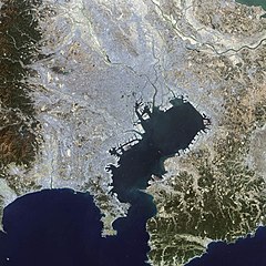
English: This false-color Landsat 7 image shows (a large part of) the greater Tokyo metropolitan area, situated on the eastern shore of the Japanese island of Honshu. The large Tokyo Bay dominates the center of this scene, and if you look closely you can see boats and their wakes on the water. The greater Tokyo area fans out in a crescent shape around the western, northern, and eastern shores of Tokyo Bay. Greater Tokyo is bordered to the west by rugged mountains and to the east by the vast expanse of the Pacific Ocean.
The greater metropolis area is comprised of Tokyo prefecture, situated on the northwestern shore of Tokyo Bay, and the three neighboring prefectures of Kanagawa to the south, Saitama to the north, and Chiba to the east and southeast across Tokyo Bay. Over the last 400 years, Japan’s National Capital Region has evolved into a large, self-governing unit consisting of 26 cities, 5 towns, and 8 villages. The region is home to some 38 million people in 2018 (more than a quarter of Japan’s whole population) in a metropolitan area spanning 14,034 square km. 日本語: 東京湾の衛星画像(2002年)人工衛星「NASA Earth Observatory」による。 |
| 日期 | |
| 來源 | Earth Observatory |
| 作者 | Image courtesy Ron Beck, USGS Eros Data Center Satellite Systems Branch |
授權條款
| 本作品由NASA創作,屬於公有領域。根據NASA的版權政策:“NASA的創作除非另有聲明否則不受版權保護。”(參見:Template:PD-USGov/zh,NASA版權政策或JPL圖像使用政策) | ||
 |
警告:
|
檔案歷史
點選日期/時間以檢視該時間的檔案版本。
| 日期/時間 | 縮圖 | 尺寸 | 使用者 | 備註 | |
|---|---|---|---|---|---|
| 目前 | 2008年11月18日 (二) 14:25 | | 1,000 × 1,000(511 KB) | Jyusin | {{Information |Description={{en|1=Tokyo}} {{ja|1=東京}} |Source=[http://earthobservatory.nasa.gov/IOTD/view.php?id=2854 Earth Observatory] |Author=NASA |Date= |Permission= |other_versions= }} <!--{{ImageUpload|full}}--> |
檔案用途
下列頁面有用到此檔案:
全域檔案使用狀況
以下其他 wiki 使用了這個檔案:
- az.wikipedia.org 的使用狀況
- de.wikipedia.org 的使用狀況
- es.wikipedia.org 的使用狀況
- fr.wikipedia.org 的使用狀況
- hu.wikipedia.org 的使用狀況
- it.wikipedia.org 的使用狀況
- ja.wikipedia.org 的使用狀況
- pt.wikipedia.org 的使用狀況
- simple.wikipedia.org 的使用狀況
- tr.wikipedia.org 的使用狀況
- vi.wikipedia.org 的使用狀況