
File:Tropical Storm Cristina 2002.jpg

預覽大小:463 × 599 像素。 其他解析度:185 × 240 像素 | 371 × 480 像素 | 593 × 768 像素 | 791 × 1,024 像素 | 1,582 × 2,048 像素 | 6,801 × 8,801 像素。
原始檔案 (6,801 × 8,801 像素,檔案大小:9.08 MB,MIME 類型:image/jpeg)
摘要
| 描述 |
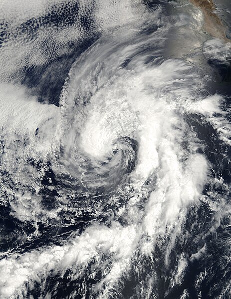
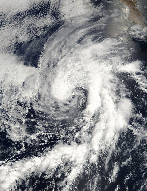
Now downgraded to a tropical depression, Tropical Storm Cristina can be seen at full strength in this true-color image taken on July 14, 2002, by the Moderate Resolution Imaging Spectroradiometer (MODIS), flying aboard NASA's Terra spacecraft. The land in the upper right-hand corner is Baja California. The typhoon, which formed to the south a few days ago, moved northward and headed toward Baja California before turning west and dissipating in the eastern Pacific. When this image was taken, the tropical storm bore sustained winds of over 63 kilometers (39 miles) per hour. Currently, sustained winds are at 46 kilometers (28 miles) per hour. |
|||||
| 日期 | ||||||
| 來源 | http://earthobservatory.nasa.gov/NaturalHazards/natural_hazards_v2.php3?img_id=4144 | |||||
| 作者 | Image courtesy Jesse Allen, NASA Earth Observatory; Data provided by the MODIS Land Rapid Response Team at NASA GSFC | |||||
| 授權許可 (重用此檔案) |
|
|||||
| 其他版本 |

.jpg)
檔案歷史
點選日期/時間以檢視該時間的檔案版本。
| 日期/時間 | 縮圖 | 尺寸 | 使用者 | 備註 | |
|---|---|---|---|---|---|
| 目前 | 2018年11月22日 (四) 21:28 | | 6,801 × 8,801(9.08 MB) | FleurDeOdile | better |
| 2010年1月2日 (六) 04:30 |  | 2,685 × 2,600(1.59 MB) | Juliancolton | Reverted to version as of 14:41, 31 August 2006 | |
| 2009年12月27日 (日) 17:45 |  | 2,685 × 2,565(1.09 MB) | Supportstorm | Fix? | |
| 2009年12月27日 (日) 17:44 |  | 2,685 × 2,565(1.09 MB) | Supportstorm | Image Touch up/ Cropped | |
| 2006年8月31日 (四) 14:41 |  | 2,685 × 2,600(1.59 MB) | Good kitty | == Summary == {{Information |Description=Now downgraded to a tropical depression, Tropical Storm Cristina can be seen at full strength in this true-color image taken on July 14, 2002, by the Moderate Resolution Imaging Spectroradiometer (MODIS), flying ab |
檔案用途
下列頁面有用到此檔案:
全域檔案使用狀況
以下其他 wiki 使用了這個檔案:
- de.wikipedia.org 的使用狀況
- en.wikipedia.org 的使用狀況
- es.wikipedia.org 的使用狀況