
File:US pennsylvanian general USGS.jpg

此為最大尺寸。
US_pennsylvanian_general_USGS.jpg (500 × 353 像素,檔案大小:22 KB,MIME 類型:image/jpeg)

|
本圖片是以PNG、GIF或JPEG格式上傳。然而,其中包含的資料或訊息,應該重新建立成可縮放向量圖形(SVG)檔案,以更有效率或更準確的方式儲存。如有可能,請上傳本圖片的SVG格式版本。在上傳之後,請修改維基各姊妹計畫中所有使用舊版圖片的條目(列在圖像連結章節中),替換為新版圖片,並在舊圖片的描述頁中加入{{Vector version available|新圖片名稱.svg}}模板,同時移除本模板。
|


摘要
| 描述 |
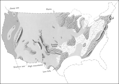
English: Generalized geographic map of the United States location in Middle Pennsylvanian time.
During the Carboniferous period, the contrast in the distribution of land and water from the ancient past to the present becomes more dramatic. The map shows the outline of the United States as it looked during the Pennsylvanian Period some 300 million years ago. It gives the appearance of reversing present-day geography. A highland which lay to the east, south, and north supplied much of the sedimentary debris that was spread over the midwestern part of the United States. The Midwest was mainly a low swampy area in which scouring rushes and fern trees grew in profusion. Sediment was carried into the region from deltas to the east. From time to time, the level of the sea fluctuated -- possibly because of glacial conditions in the Southern Hemisphere. Swamps were flooded, and forests were destroyed. Slowly, layers rich in tree stumps, spores, branches, and leaves were deposited. Later, heat and pressure changed these layers into the coal beds that are so extensive in Illinois, Kentucky, Pennsylvania, West Virginia, and Tennessee. To the west, marine limestones, sandstones, and shales accumulated in shallow seas whose vast expanses were dotted with shoals and islands. Some of the very large islands were formed by the buckling and uplifting of parts of the Earth's crust. |
| 日期 | 2001年前後 |
| 來源 | http://pubs.usgs.gov/gip/continents/pennmap.jpg |
| 作者 |
授權條款
|
|
原始上傳日誌
The original description page was here. All following user names refer to en.wikipedia.
| 日期/時間 | 尺寸 | 使用者 | 備註 |
|---|---|---|---|
| 2005-04-15 02:48 | 500×353× (22509 bytes) | SEWilco | Generalized geographic map of the [[United States]] in [[Middle Pennsylvanian]] time. In the Coal Age, the contrast in the distribution of land and water from the ancient past to the present becomes more dramatic. The map shows the outline of the United |
The original description page was here. All following user names refer to el.wikipedia.
| 日期/時間 | 尺寸 | 使用者 | 備註 |
|---|---|---|---|
| 2016-01-16 16:00 | 500×353× (22509 bytes) | Kalogeropoulos | {{Πληροφορίες εικόνας |Περιγραφή=Γενικός γεωγραφικός χάρτης των [[ΗΠΑ]] κατά τη μέση [[Πενσυλβάνια εποχή]] |Πηγή=http://pubs.usgs.gov/gip/continents/pennmap.jpg |Η... |
檔案歷史
點選日期/時間以檢視該時間的檔案版本。
| 日期/時間 | 縮圖 | 尺寸 | 使用者 | 備註 | |
|---|---|---|---|---|---|
| 目前 | 2016年10月22日 (六) 07:04 | | 500 × 353(22 KB) | MARKELLOS | Transferred from el.wikipedia |
檔案用途
下列頁面有用到此檔案:
全域檔案使用狀況
以下其他 wiki 使用了這個檔案:
- el.wikipedia.org 的使用狀況
- en.wikipedia.org 的使用狀況
- fa.wikipedia.org 的使用狀況