
File:Karte konstanz in deutschland.png
此为最大尺寸。
Karte_konstanz_in_deutschland.png (188 × 235像素,文件大小:5 KB,MIME类型:image/png)
摘要
| 描述 |
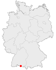
Deutsch: Karte von Deutschland mit den Grenzen der 16 Bundesländer
Quadratische Plattkarte, N-S-Streckung 150 %. Geographische Begrenzung der Karte:
English: Map of Germany with the borders of the 16 federal states
Equirectangular projection, N/S stretching 150 %. Geographic limits of the map:
|
||
| 日期 | |||
| 来源 | 自己的作品 | ||
| 作者 | NordNordWest | ||
| 授权 (二次使用本文件) |
This image was generated with OpenGeoDB. The information there is placed in the public domain, images generated from OpenGeoDB are derivative works without passing the threshold of creativity, they are therefore also public domain.
|
||
| 其他版本 |
|


|
|
文件历史
点击某个日期/时间查看对应时刻的文件。
| 日期/时间 | 缩略图 | 大小 | 用户 | 备注 | |
|---|---|---|---|---|---|
| 当前 | 2005年12月23日 (五) 05:52 | | 188 × 235(5 KB) | Roo72 | from de Wiki category:maps |
文件用途
以下页面使用本文件:
全域文件用途
以下其他wiki使用此文件:
- af.wikipedia.org上的用途
- ja.wikipedia.org上的用途
- pl.wikivoyage.org上的用途