庞蒂亚克 (密歇根州)
外观
| 此條目部分链接不符合格式手冊規範。跨語言链接及章節標題等處的链接可能需要清理。 (2015年12月13日) |
| 庞蒂亚克 | |
|---|---|
| 市 | |
| Pontiac | |
 | |
| 坐标:42°38′46″N 83°17′33″W / 42.6461°N 83.2925°W | |
| 国家 | 美国 |
| 州 | 密歇根州 |
| 郡 | 奧克蘭郡 |
| Settled | 1818 |
| Incorporated | 1861 |
| 面积[1] | |
| • 总计 | 20.28 平方英里(52.52 平方公里) |
| • 陸地 | 19.97 平方英里(51.72 平方公里) |
| • 水域 | 0.31 平方英里(0.80 平方公里) |
| 海拔 | 922 英尺(281 公尺) |
| 人口(2010) | |
| • 總計 | 59,515人 |
| • 估计(2012[2]) | 60,175 |
| • 密度 | 2,980.2人/平方英里(1,150.7人/平方公里) |
| 时区 | Eastern (EST)(UTC-5) |
| • 夏时制 | EDT(UTC-4) |
| 網站 | http://www.pontiac.mi.us |
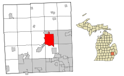
庞蒂亚克(Pontiac)是美国密歇根州一座城市,位于底特律都会区。到2010年,该市人口 59,515. 它是奧克蘭郡的郡治。[3]
该市得名于庞蒂亚克酋长。通用汽车公司曾在此设厂,生产的庞蒂克汽车以该市的名称命名。
该市总面积20.28平方英里(52.52平方公里),其中陆地面积19.97平方英里(51.72平方公里),水域面积0.31平方英里(0.80平方公里)[1]。
| 歷史人口數 | |||
|---|---|---|---|
| 調查年 | 人口 | %± | |
| 1840年 | 1,904 | — | |
| 1850年 | 1,681 | −11.7% | |
| 1860年 | 2,575 | 53.2% | |
| 1870年 | 4,867 | 89.0% | |
| 1880年 | 4,509 | −7.4% | |
| 1890年 | 6,200 | 37.5% | |
| 1900年 | 9,769 | 57.6% | |
| 1910年 | 14,532 | 48.8% | |
| 1920年 | 34,273 | 135.8% | |
| 1930年 | 64,928 | 89.4% | |
| 1940年 | 66,626 | 2.6% | |
| 1950年 | 73,681 | 10.6% | |
| 1960年 | 82,223 | 11.6% | |
| 1970年 | 85,279 | 3.7% | |
| 1980年 | 76,715 | −10.0% | |
| 1990年 | 71,166 | −7.2% | |
| 2000年 | 66,337 | −6.8% | |
| 2010年 | 59,515 | −10.3% | |
| 2012年估計 | 60,175 | 1.1% | |

教育
参考
- ^ 1.0 1.1 US Gazetteer files 2010. United States Census Bureau. [2012-11-25]. (原始内容存档于2011-02-20).
- ^ Population Estimates. United States Census Bureau. [2013-06-03]. (原始内容存档于2013-06-17).
- ^ Find a County. National Association of Counties. [2011-06-07].
- ^ Murray, Diana Dillaber. "Law being proposed could dissolve Pontiac schools, other struggling districts." Oakland Press (EN). June 12, 2013. Retrieved on May 7, 2014. "Pontiac school district spreads from Pontiac into portions of seven surrounding communities including Auburn Hills, Sylvan Lake, Lake Angeles and townships of Bloomfield, Orion, Waterford and West Bloomfield."
