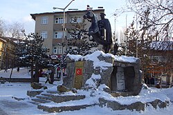
薩勒卡默什
外观
薩勒卡默什是土耳其的城鎮,由卡爾斯省負責管轄,位於該國東北部,面積1,732平方公里,海拔高度約2,100米,受大陸性氣候影響,2008年人口21,438。
| 薩勒卡默什 | |
|---|---|
 | |
| 坐标:40°20′17″N 42°34′23″E / 40.33806°N 42.57306°E | |
| 國家 | |
| 行政區 | 卡爾斯 |
| 政府 | |
| • 市長 | Göksal Toksoy (正义与发展党 (土耳其)) |
| • 區長 | Yusuf İzzet Karaman |
| 面积[1] | |
| • 面積 | 1,971.01 平方公里(761.01 平方英里) |
| 人口(2012年)[2] | |
| • 市区 | 19,727 |
| • 區域 | 50,308 |
| Post Code | 36500 |
| 網站 | www.sarikamis.bel.tr |
参考文献
[编辑]- ^ Area of regions (including lakes), km². Regional Statistics Database. Turkish Statistical Institute. 2002 [2013-03-05].
- ^ Population of province/district centers and towns/villages by districts - 2012. Address Based Population Registration System (ABPRS) Database. Turkish Statistical Institute. [2013-02-27].
| 这是一篇與土耳其地理相關的小作品。您可以通过编辑或修订扩充其内容。 |

