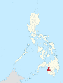
馬京達瑙省
外观
| 馬京達瑙省 ماڬينداناو | |||||||||||
|---|---|---|---|---|---|---|---|---|---|---|---|
| 菲律賓的省 | |||||||||||
| 1973年—2022年 | |||||||||||
 馬京達瑙省於菲律賓位置圖 | |||||||||||
| 坐标:07°08′N 124°18′E / 7.133°N 124.300°E | |||||||||||
| 國家 | the Philippines | ||||||||||
| 首府 | 沙里夫阿瓜克 (first) Buluan (last) | ||||||||||
| 面积 | |||||||||||
• 2016[1] | 4,871.60平方公里(1,880.94平方英里) | ||||||||||
| 人口 | |||||||||||
• 2020 [2] | 1,667,258 | ||||||||||
| 政府 | |||||||||||
| 政區首長 | |||||||||||
• 1973–1975 | Simeon Datumanong (first) | ||||||||||
• 2019–2022 | Bai Mariam Mangudadatu (last) | ||||||||||
| 歷史 | |||||||||||
• 成立 | 1973年11月22日 | ||||||||||
| 2022年9月17日 | |||||||||||
• End of transition period | 2023年1月9日 | ||||||||||
| 包含于 | |||||||||||
| • Region | Central Mindanao (1973–1989) Autonomous Region in Muslim Mindanao (1989–2019) Bangsamoro Autonomous Region in Muslim Mindanao (2019–2022) | ||||||||||
| 分區 | |||||||||||
| • 類型 | LGUs | ||||||||||
| • 單元 | 37 Municipalities and City (including Cotabato City) 508 barangays | ||||||||||
| |||||||||||
馬京達瑙省[3][4](英文:Maguindanao),為菲律賓棉蘭老穆斯林自治區的一省,下轄31個自治市,面積7,172平方公里,人口1,273,715人(2007年),首府為沙里夫阿瓜克(Shariff Aguak)。
2009年11月23日該省發生一起政治屠殺,馬京達瑙省南部的安帕圖安鎮副鎮長埃斯梅爾·曼古達達圖圖(Esmael Mangudadatu)參選省長,當日他的家人在遞交參選申請時連同隨行記者等多人遭擄走並殺害,死亡人數達到58人。[5]
參考文獻
- ^ ARMM Regional Profile. Regional Board of Investments (RBOI) of the Autonomous Region in Muslim Mindanao (ARMM). [June 22, 2016]. (There seems to be major discrepancies among authoritative sources: 972,904 ha (NSCB); 6,565 km² (Historical Dictionary of the Philippines); 5,176.1 km² (NAMRIA))
- ^ Census of Population (2015). Highlights of the Philippine Population 2015 Census of Population. PSA. [2016-06-20].
- ^ 民政部地名研究所 (编). Maguindanao,Prov.of 马京达瑙省 [菲]. 世界地名译名词典. 北京: 中国社会出版社: 1664. 2017-05. ISBN 978-7-5087-5525-0. OCLC 1121629943. OL 28272719M. NLC 009152391.(简体中文)
- ^ 馬京達瑙省 Maguindanao, Province of. 樂詞網. 國家教育研究院 (中文(臺灣)). (正體中文)
- ^ 菲律宾马京达瑙大屠杀案六周年:尚无一人被定罪. 中新網. 2015-11-23 [2015-11-24]. (原始内容存档于2020-07-03).


