
File:AS15-M-2075.jpg
本预览的尺寸:600 × 600像素。 其他分辨率:240 × 240像素 | 480 × 480像素 | 1,012 × 1,012像素。
原始文件 (1,012 × 1,012像素,文件大小:297 KB,MIME类型:image/jpeg)
摘要
| 描述 |
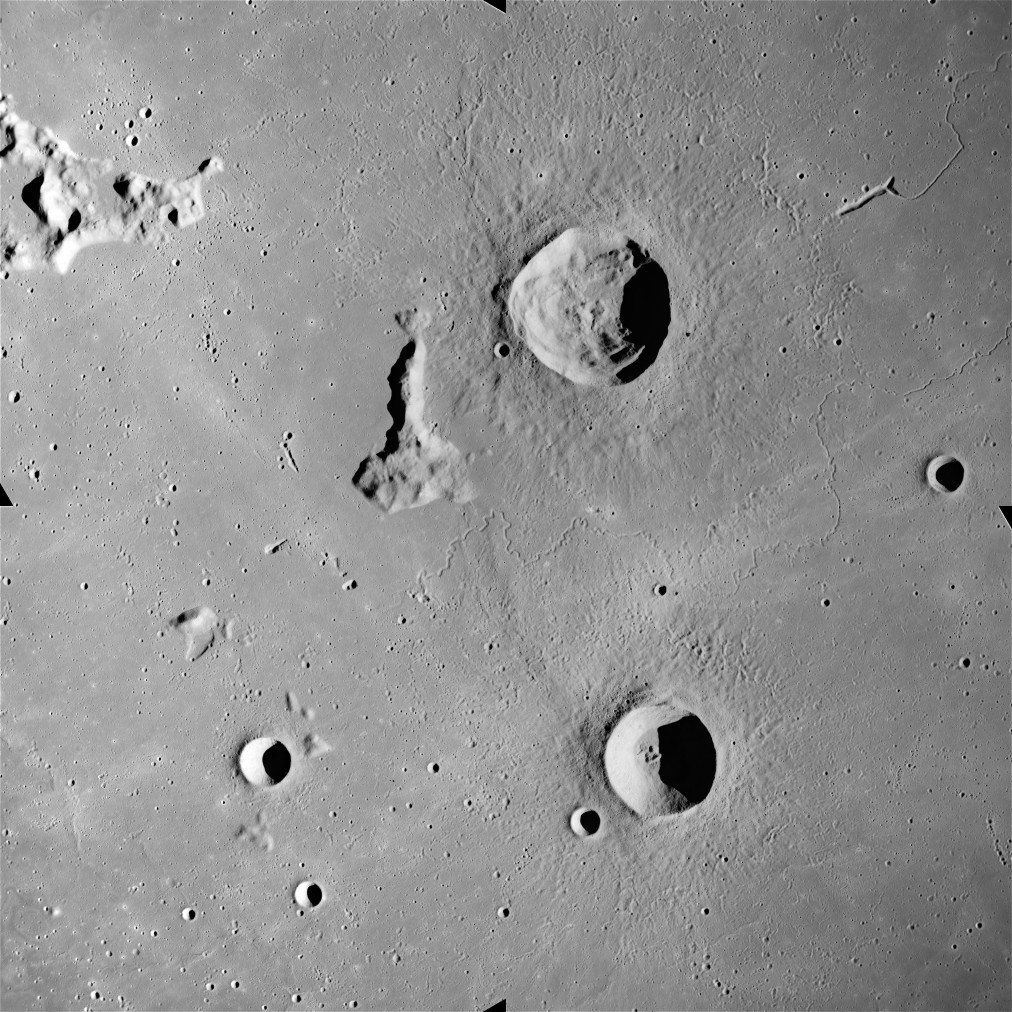
English: This image was created Apollo 15 mapping metric sequence, sequence #60. It is at selenographic coordinates 28.50° N, 35° W. The prominent crater in the upper half is Delisle, and the crater in the lower half is Diophantus. Just visible between the two is the sinuous rille named Rima Diophantus. To the northeast of Delisle crater is another rille named Rima Delisle. To the southwest of Deslisle is Mons Delisle, a ridge in the mare surface.
This image was created by reducing the hi-res. copy to 25% size, then rotating 90° counter-clockwise so that north is to the top.
Русский: Кратеры Диофант, Делиль, Арцимович, Федоров, борозда Диофанта, борозда Делиля на Луне. |
| 来源 |
Lunar & Planetary Institute, http://www.lpi.usra.edu/resources/apollo/frame/?AS15-M-2075[1] |
| 作者 | NASA |
本图像或视频收录于美国国家航空航天局 (NASA)休斯顿太空中心(Johnson Space Center),其照片编号是: AS15-M-2075 此标签不表示文件的著作权状态。任何文件在附有此标签的同時还需要一个有效的著作权标签。请参阅许可协议说明页面以了解更多信息。 其他语言:
|
许可协议
| 本文件完全由NASA创作,在美国属于公有领域。根据NASA的版权方针,NASA的材料除非另有声明否则不受版权保护。(参见Template:PD-USGov/zh、NASA版权方针页面或JPL图片使用方针。) | ||
 |
警告:
|
| 註解 | 該圖片含有註解:在維基媒體共享資源上查看註解 |
文件历史
点击某个日期/时间查看对应时刻的文件。
| 日期/时间 | 缩略图 | 大小 | 用户 | 备注 | |
|---|---|---|---|---|---|
| 当前 | 2017年8月10日 (四) 14:29 | | 1,012 × 1,012(297 KB) | Jstuby | higher resolution, from ASU |
| 2006年1月20日 (五) 20:01 |  | 604 × 600(83 KB) | RJHall | Used the Hi-Res version to improve the graphics. | |
| 2006年1月19日 (四) 23:34 |  | 454 × 450(33 KB) | RJHall | Delisle and Diophantus craters. |
文件用途
全域文件用途
以下其他wiki使用此文件:
- ca.wikipedia.org上的用途
- ce.wikipedia.org上的用途
- cs.wikipedia.org上的用途
- da.wikipedia.org上的用途
- de.wikipedia.org上的用途
- en.wikipedia.org上的用途
- es.wikipedia.org上的用途
- fa.wikipedia.org上的用途
- fr.wikipedia.org上的用途
- it.wikipedia.org上的用途
- lb.wikipedia.org上的用途
- pl.wikipedia.org上的用途
- ro.wikipedia.org上的用途
- ru.wikipedia.org上的用途
- sv.wikipedia.org上的用途
- tt.wikipedia.org上的用途
- www.wikidata.org上的用途