
File:Area code ND.png
此为最大尺寸。
Area_code_ND.png (300 × 200像素,文件大小:9 KB,MIME类型:image/png)
摘要
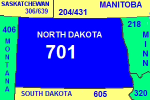
| 描述 | Map of North Dakota showing area code in blue, with adjacent states and provinces (although they are incorrectly labelled. Alberta is labelled where it should say Saskatchewan). |
| 来源 | NationalAtlas.gov |
| 作者 |
许可协议
此作品在美国属于公有领域,因为其是由美国政府的官员或雇员,基于其个人公务目的制作的作品,参考美国法典第17篇第1章第105条。
注意︰本模板仅适用于美国联邦政府的原创作品,不适用于任何美国州、属地、联邦个体、县、市或任何次级政府的作品。本模板也不适用于1978年以后由美国邮政署出版的邮票图案(参看美国版权局实践纲领第313.6(C)(1)条)。也不适用于部分美国硬币;参看美国铸币局使用条款。 |
 | |
| 本文件已被确认为免除已知的著作权法限制(包括所有相关权利)。 | ||
文件历史
点击某个日期/时间查看对应时刻的文件。
| 日期/时间 | 缩略图 | 大小 | 用户 | 备注 | |
|---|---|---|---|---|---|
| 当前 | 2018年9月3日 (一) 08:31 | | 300 × 200(9 KB) | LaundryPizza03 | Image got blurry when the province name was corrected. |
| 2017年7月15日 (六) 20:02 |  | 300 × 200(50 KB) | Ineuw | reduced size to the original | |
| 2017年7月15日 (六) 19:50 |  | 960 × 640(296 KB) | Ineuw | changed incorrect province from Alberta to Saskatchewan | |
| 2013年1月31日 (四) 02:54 |  | 300 × 200(10 KB) | Rfc1394 | Add new area codes for AB and MB; add state and province names | |
| 2007年3月12日 (一) 00:42 |  | 300 × 200(4 KB) | Rfc1394 | Map of North Dakota showing area code in blue, with adjacent states and provinces. From NationalAtlas.gov Category:Maps of North Dakota Category:Area code maps of the United States |
文件用途
以下2个页面使用本文件:
全域文件用途
以下其他wiki使用此文件:
- en.wikipedia.org上的用途
- ro.wikipedia.org上的用途
- simple.wikipedia.org上的用途