
File:Area code WY.png
此为最大尺寸。
Area_code_WY.png (420 × 275像素,文件大小:9 KB,MIME类型:image/png)

|
此map图片可使用矢量图形重新创建为SVG文件。这具有很多好处;更多信息请参见共享资源:待清理媒体。如果存在此图片的SVG格式,请将其上传,然后将此模板替换为
{{vector version available|新图片名称}}。
建议您将SVG命名为“Area code WY.svg”,这样在使用Vector version available(或Vva)模板时就不需要填写新图片名称参数。 |
摘要
| 描述 |
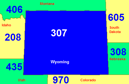
English: Map of Wyoming in blue with area codes for it and surrounding states. |
| 来源 |
English: U.S. Government's Tiger Map Server |
| 作者 |
许可协议
This image or file is a work of a United States Census Bureau employee, taken or made as part of that person's official duties. As a work of the U.S. federal government, the image is in the public domain.
|
 |
文件历史
点击某个日期/时间查看对应时刻的文件。
| 日期/时间 | 缩略图 | 大小 | 用户 | 备注 | |
|---|---|---|---|---|---|
| 当前 | 2007年7月25日 (三) 15:14 | | 420 × 275(9 KB) | Rfc1394 | Add state names |
| 2007年3月11日 (日) 14:58 |  | 420 × 275(7 KB) | Rfc1394 | Map of Wyoming in blue with area codes for it and surrounding states. From U.S. Government's [http://tiger.census.gov Tiger Map Server]. {{Pd-census}} Category:Maps of Wyoming Category:Area code maps of the United States |
文件用途
以下页面使用本文件:
全域文件用途
以下其他wiki使用此文件:
- en.wikipedia.org上的用途
- simple.wikipedia.org上的用途