
File:Arnhem land locator.png

本预览的尺寸:282 × 600像素。 其他分辨率:113 × 240像素 | 489 × 1,040像素。
原始文件 (489 × 1,040像素,文件大小:227 KB,MIME类型:image/png)

|
此locator map图片可使用矢量图形重新创建为SVG文件。这具有很多好处;更多信息请参见共享资源:待清理媒体。如果存在此图片的SVG格式,请将其上传,然后将此模板替换为
{{vector version available|新图片名称}}。
建议您将SVG命名为“Arnhem land locator.svg”,这样在使用Vector version available(或Vva)模板时就不需要填写新图片名称参数。 |
摘要
| 描述 |
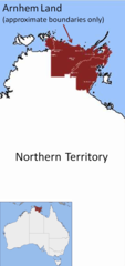
English: Location map showing approximate boundaries of Arnhem Land, Northern Territory, Australia |
| 日期 | |
| 来源 | 自己的作品 |
| 作者 | Glen Dillon |
Note: boundaries are approximate only. Also - Groote Eylandt and Goulburn Island are also part of Arnhem Land.
许可协议
| 我,本作品著作权人,释出本作品至公有领域。这适用于全世界。 在一些国家这可能不合法;如果是这样的话,那么: 我无条件地授予任何人以任何目的使用本作品的权利,除非这些条件是法律规定所必需的。 |
文件历史
点击某个日期/时间查看对应时刻的文件。
| 日期/时间 | 缩略图 | 大小 | 用户 | 备注 | |
|---|---|---|---|---|---|
| 当前 | 2008年9月9日 (二) 05:10 | | 489 × 1,040(227 KB) | Glen Dillon | {{Information |Description={{en|1=Location map showing approximate boundaries of Anrhem Land, Northern Territory, Australia}} |Source=Own work by uploader |Author=Glen Dillon |Date=9 September 2008 |Permission=see below |other_version |
文件用途
没有页面链接到本图像。
全域文件用途
以下其他wiki使用此文件:
- ar.wikipedia.org上的用途
- en.wikipedia.org上的用途
- et.wikipedia.org上的用途
- pfl.wikipedia.org上的用途
- pt.wikipedia.org上的用途
- simple.wikipedia.org上的用途