
File:Barentsz Full Map.jpg

本预览的尺寸:800 × 594像素。 其他分辨率:320 × 237像素 | 640 × 475像素 | 1,000 × 742像素。
原始文件 (1,000 × 742像素,文件大小:258 KB,MIME类型:image/jpeg)
摘要
| 描述 |
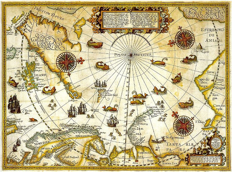
1598 map of the hree Arctic voyages (1594–1596) by Willem Barentsz. Delineatio cartae trium navigantium per Bataves, ad Septentrionalem plagam, Norvegiae, Moscoviae et novae Semblae Autore Wilhelmo Bernardo [1] [2] |
| 日期 | |
| 来源 | immediate source unknown, uploaded 2007 |
| 作者 | Willem Barentsz (Wilhelmus Bernardus) |
| 授权 (二次使用本文件) |
Public domain (over 70 years since creator's death) |
| 其他版本 |
|

.jpg)
_door_Willem_Barendsz_(titel_op_object),_NG-800.jpg)


许可协议
|
本作品在其来源国以及其他著作权期限是作者逝世后100年或以下的国家和地区属于公有领域。 | |
| 本文件已被确认为免除已知的著作权法限制(包括所有相关权利)。 | |
文件历史
点击某个日期/时间查看对应时刻的文件。
| 日期/时间 | 缩略图 | 大小 | 用户 | 备注 | |
|---|---|---|---|---|---|
| 当前 | 2007年12月5日 (三) 22:20 | | 1,000 × 742(258 KB) | Sherurcij | {{Information |Description=Portion of 1599 map of Arctic exploration by Willem Barentsz. Spitsbergen, here mapped for the first time, is indicated as "Het Nieuwe Land" (Dutch for "the New Land"), center-left. |Source=[http://www.ub.uit.no/northernlights/e |
文件用途
没有页面链接到本图像。
全域文件用途
以下其他wiki使用此文件:
- ar.wikipedia.org上的用途
- fr.wikipedia.org上的用途
- gcr.wikipedia.org上的用途
- kk.wikipedia.org上的用途
- nrm.wikipedia.org上的用途
- ru.wikipedia.org上的用途