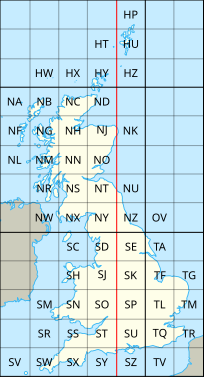
原始文件 (SVG文件,尺寸为204 × 377像素,文件大小:78 KB)
您可以自由地:
共享 – 复制、发行并传播本作品修改 – 改编作品
惟须遵守下列条件:
署名 – 您必须对作品进行署名,提供授权条款的链接,并说明是否对原始内容进行了更改。您可以用任何合理的方式来署名,但不得以任何方式表明许可人认可您或您的使用。相同方式共享 – 如果您再混合、转换或者基于本作品进行创作,您必须以与原先许可协议相同或相兼容的许可协议 分发您贡献的作品。 https://creativecommons.org/licenses/by-sa/3.0 CC BY-SA 3.0 Creative Commons Attribution-Share Alike 3.0 true true
This image is a derivative work of the following images:
File:National_Grid_for_Great_Britain_with_central_meridian.gif licensed with Cc-by-sa-3.0-migrated, GFDL
2010-02-23T23:22:36Z MansLaughter 235x434 (8630 Bytes) {{Information |Description= |Source=*[[:File:National_Grid_for_Great_Britain_with_central_meridian.png|]] |Date=2010-02-23 23:19 (UTC) |Author=*[[:File:National_Grid_for_Great_Britain_with_central_meridian.png|]]: ~~~ *deriva File:United_Kingdom_and_North-West_France.svg licensed with Cc-by-sa-3.0
2010-04-26T11:43:17Z Pethrus 270x482 (59564 Bytes) {{Information |Description={{en|Map of the United Kingdom and the North-East of France}}{{fr|Carte des îles britanniques et du Nord-Ouest de la France}} |Source=*[[:File:Europe_blank_laea_location_map.svg|]] |Date=2010-04-26 Uploaded with derivativeFX
文件历史
点击某个日期/时间查看对应时刻的文件。
日期/时间 缩略图 大小 用户 备注 当前 2010年7月8日 (四) 20:06 204 × 377(78 KB) Nandhp Remove temporary data (reference to original raster image) 2010年7月8日 (四) 20:05 204 × 377(83 KB) Nandhp {{Information |Description={{en|The en:British national grid reference system }} |Source=*File:National_Grid_for_Great_Britain_with_central_meridian.gif *File:United_Kingdom_and_North-West_France.svg |Date=2010-07-08 20:03 (UTC) |Author=*[
文件用途
全域文件用途
以下其他wiki使用此文件:
de.wikipedia.org上的用途
en.wikipedia.org上的用途
en.wikivoyage.org上的用途
fr.wikipedia.org上的用途
nl.wikipedia.org上的用途
simple.wikipedia.org上的用途
此文件中包含有扩展的信息。这些信息可能是由数码相机或扫描仪在创建或数字化过程中所添加。
如果此文件的源文件已经被修改,一些信息在修改后的文件中将不能完全反映出来。


