
File:CanalZone.png

本预览的尺寸:440 × 599像素。 其他分辨率:176 × 240像素 | 520 × 708像素。
原始文件 (520 × 708像素,文件大小:265 KB,MIME类型:image/png)
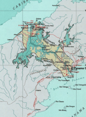
Map of the Panama Canal Zone. from the National Atlas archive copy at the Wayback Machine via American Memory.
本地圖取自美國國家地圖集的某個版本。國家地圖集的絕大多數作品是美國聯邦政府的作品,因此屬於公有領域。
連結網址︰ NationalAtlas.gov | 1970年印刷版︰ 國會檔案館, Perry-Castañeda圖書館
|
原始上传日志
| 日期/时间 | 大小 | 用户 | 备注 |
|---|---|---|---|
| 2005年4月29日, 04:29:04 | 520 × 708 (314279 bytes) | Hoshie (留言 · 贡献) | Map of the Panama Canal Zone. from the [http://www.nationalatlas.gov/ National Atlas] via [http://memory.loc.gov/ammem/gmdhtml/census3.html American Memory]. {{PD-USGov-Atlas}} |
文件历史
点击某个日期/时间查看对应时刻的文件。
| 日期/时间 | 缩略图 | 大小 | 用户 | 备注 | |
|---|---|---|---|---|---|
| 当前 | 2014年10月1日 (三) 09:24 | | 520 × 708(265 KB) | RokerHRO | optipng -o7 → 23.74% decrease |
| 2014年8月29日 (五) 10:52 |  | 520 × 708(348 KB) | GifTagger | Bot: Converting file to superior PNG file. (Source: CanalZone.gif). This GIF was problematic due to non-greyscale color table. |
文件用途
以下页面使用本文件:
全域文件用途
以下其他wiki使用此文件:
- ang.wikipedia.org上的用途
- ar.wikipedia.org上的用途
- be.wikipedia.org上的用途
- bg.wikipedia.org上的用途
- bn.wikipedia.org上的用途
- ca.wikipedia.org上的用途
- cs.wikipedia.org上的用途
- da.wikipedia.org上的用途
- de.wikipedia.org上的用途
- en.wikipedia.org上的用途
- eo.wikipedia.org上的用途
- es.wikipedia.org上的用途
- fa.wikipedia.org上的用途
- fr.wikipedia.org上的用途
- he.wikipedia.org上的用途
- hu.wikipedia.org上的用途
- id.wikipedia.org上的用途
- it.wikipedia.org上的用途
- ja.wikipedia.org上的用途
- ka.wikipedia.org上的用途
- ko.wikipedia.org上的用途
查看本文件的更多全域用途。