
File:Caribbean Plate map-fr.png
此为最大尺寸。
Caribbean_Plate_map-fr.png (766 × 442像素,文件大小:95 KB,MIME类型:image/png)
| 描述 |
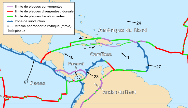
Français : Carte de la plaque des caraïbes English: Map of the Caribbean Plate |
| 日期 | |
| 来源 | Cropped version by myself of Image:Tectonic_plates_boundaries_detailed-fr.svg created by Sting under CC-BY-SA |
| 作者 | Sting and Rémih |
| 授权 (二次使用本文件) |
本文件采用知识共享署名-相同方式共享 2.5 通用许可协议授权。
|
| 其他版本 |
Scaled version of  |
文件历史
点击某个日期/时间查看对应时刻的文件。
| 日期/时间 | 缩略图 | 大小 | 用户 | 备注 | |
|---|---|---|---|---|---|
| 当前 | 2010年1月23日 (六) 13:56 | | 766 × 442(95 KB) | Toony | |
| 2006年11月18日 (六) 22:55 |  | 787 × 475(330 KB) | Rémih | {{Information |Description={{fr|Carte de la plaque des caraïbes}}{{en|Map of the Caribbean Plate}} |Source=Cropped version by myself of Image:Tectonic_plates_boundaries_detailed-fr.svg created by Sting under CC-BY-SA |Date=18/11/2006 |
文件用途
以下页面使用本文件:
全域文件用途
以下其他wiki使用此文件:
- azb.wikipedia.org上的用途
- fr.wikipedia.org上的用途
- ht.wikipedia.org上的用途
- nl.wikipedia.org上的用途
- uk.wikipedia.org上的用途